Online Links:
| Value | Definition |
|---|---|
| H2O | water |
| Jb | Massive basalt and diabase |
| Jgb | Gabbro |
| Jpb | Pillow basalt and basalt breccia |
| Jpb? | Pillow basalt and basalt breccia, identification uncertain |
| Jsv | Keratophyre and quartz keratophyre |
| KJf | Undivided Franciscan complex rocks |
| KJfm | Franciscan complex, melange |
| KJfs | Franciscan complex, undivided sandstone |
| KJfy | Franciscan complex, metasandstone of the Yolla Bolly terrane |
| KJk | Knoxville Formation |
| KJkc | Knoxville Formation, conglomerate beds |
| KJkv | Knoxville Formation, volcanoclastic breccia |
| Kc | Conglomerate interbeds (Cretaceous) |
| Kcg | Redwood Canyon Formation, conglomerate beds |
| Kcs | Massive quartz arenite (Cretaceous) |
| Kcv | Unnamed sandstone, conglomerate, and shale of the Castro Valley area (Late Cretaceous) |
| Kfa | Franciscan complex, sandstone of the Alcatraz terrane |
| Kfgm | Franciscan complex, quartz diorite of the Novato Quarry terrane |
| Kfn | Franciscan complex, sandstone of the Novato Quarry terrane |
| Kjm | Joaquin Miller Formation |
| Ko | Oakland Formation |
| Kp | Pinehurst Shale |
| Kr | Redwood Canyon Formation |
| Ksc | Shephard Creek Formation |
| Ksh | Siltstone and shale (Cretaceous) |
| Kslt | Redwood Canyon Formation, siltstone beds |
| Kss | Unnamed sandstone in the Oakland Hills (Cretaceous) |
| Ku | Undivided Great Valley complex strata |
| Kus | Sandstone, siltstone, and shale (Cretaceous) |
| QTi? | Irvington gravels, identification uncertain |
| QTu | Undifferentiated continental gravels (Pleistocene and Pliocene) |
| Qds | Dune sand |
| Qhaf | Alluvial fan and fluvial deposits (Holocene) |
| Qhaf1 | Younger alluvial fan deposits |
| Qhasc | Artificial stream channels |
| Qhb | Basin deposits |
| Qhbm | Bay mud |
| Qhbr | Beach ridge deposits |
| Qhbs | Basin deposits, salt affected |
| Qhfp | Floodplain deposits |
| Qhl | Natural levee deposits |
| Qhsc | Stream channel deposits |
| Qls | Landslide deposits |
| Qms | Merrit sand |
| Qmt | Marine terrace deposits |
| Qpaf | Alluvial fan and fluvial deposits (Pleistocene) |
| Qpaf1 | Alluvial terrace deposits |
| Qpoaf | Older alluvial fan deposits |
| Ta | Unnamed glauconitic sandstone (Paleocene) |
| Tbd | Briones Formation, D member |
| Tbe | Briones Formation, E member |
| Tbf | Briones Formation, F member |
| Tbg | Briones Formation, G member |
| Tbgc | Briones Formation, G member, conglomerate beds |
| Tbgl | Briones Formation, G member, limestone beds |
| Tbh | Briones Formation, Hercules shale member |
| Tbi | Briones Formation, I member |
| Tbl | Briones Formation, lower member |
| Tbp | Bald Peak Basalt |
| Tbr | Briones Formation |
| Tbu | Briones Formation, upper member |
| Tc | Cierbo Sandstone |
| Tcc | Claremont Chert |
| Tccs | Claremont Shale, sandstone and siltstone beds |
| Tccs? | Claremont Shale, sandstone and siltstone beds, identification uncertain |
| Tcgl | Conglomerate, sandstone, siltstone (Pliocene and Miocene) |
| Tcglt | Rhyolite tuff interbeds (Pliocene) |
| Tchs | Unnamed shale (Miocene) |
| Tcs | Claremont Shale |
| Tdi | Diatomite (Miocene) |
| Tes | Unnamed mudstone (Eocene) |
| Tes? | Unnamed mudstone (Eocene), identification uncertain |
| Tgvt | Green Valley and Tassajara Formations |
| Th | Hambre Sandstone |
| Th? | Hambre Sandstone, identification uncertain |
| Tlt | Lafayette Tuff |
| Tmb | Moraga Formation |
| Tmll | Mullholland Formation, lower member |
| Tmls | Mullholland Formation, lower member, sandstone marker beds |
| Tmlu | Mullholland Formation, upper member |
| Tmru | Muir Sandstone, upper member |
| Tms | Moraga Formation, interbedded sandstone |
| Tmu | Mudstone, shale, and siltstone (Miocene) |
| Tn | Neroly Sandstone |
| Tn? | Neroly Sandstone, identification uncertain |
| To | Oursan Sandstone |
| To? | Oursan Sandstone, identification uncertain |
| Tor | Orinda Formation |
| Tr | Rodeo Shale |
| Tr? | Rodeo Shale, identification uncertain |
| Tro | Rodeo Shale, Hambre Sandstone, Tice Shale, and Oursan Sandstone, undivided |
| Ts | Sobrante Sandstone |
| Ts? | Sobrante Sandstone, identification uncertain |
| Tsa | Sandstone (Miocene) |
| Tshc | Shale and claystone (Eocene) |
| Tsm | Unnamed glauconitic mudstone (Miocene and Oligocene?) |
| Tsms | Interbedded sandstone (Miocene and Oligocene?) |
| Tsr | San Ramon Sandstone |
| Tss | Sandstone (Miocene) |
| Tst | Siesta Formation |
| Tt | Tice Shale |
| Tt? | Tice Shale, identification uncertain |
| Tts | Tuffaceous sandstone (Miocene? or Oligocene) |
| Tub | Interbedded basalt (Miocene) |
| Tuc | Unnamed conglomerate (Miocene) |
| Tul | Interbedded limestone (Miocene) |
| Tus | Unnamed sedimentary and volcanic rocks (Miocene) |
| Tush | Unnamed gray mudstone (Miocene) |
| Tvh | Vine Hill Sandstone |
| Tvhl | Vine Hill Sandstone, lower member |
| Tvhu | Vine Hill Sandstone, upper member |
| af | Artificial fill |
| alf | Artificial levee fill |
| fc | Franciscan complex, melange, chert block |
| fg | Franciscan complex, melange, greenstone block |
| fm | Franciscan complex, melange, schist block |
| fs | Franciscan complex, melange, sandstone block |
| sc | Silica-carbonate rock |
| sp | Serpentinite |
| sp? | Serpentinite, identification uncertain |
| spm | Serpentinite matrix melange |
| Value | Definition |
|---|---|
| contact, approx. located | Boundary between two mapped units that retains the original depositional or intrusive relationship (i.e. not faulted). The contact has not been observed, so it is not well-located as described in Positional_Accuracy, but the location is constrained to be within about 2 mm at map scale (1:24,000) or within about 48 meters on the ground. |
| contact, certain | Boundary between two mapped units that retains the original depositional or intrusive relationship (i.e. not faulted). The contact has been observed or is closely constrained, so it is well-located as described in Positional_Accuracy. |
| contact, inferred | Boundary between two mapped units that retains the original depositional or intrusive relationship (i.e. not faulted). The contact has not been observed, so it is not well-located as described in Positional_Accuracy, but the location is constrained to be within about 5 mm at map scale (1:24,000) or within about 120 meters on the ground. The existence of the fault is inferred from structural and stratigraphic relationships observed elsewhere. |
| contact, inferred, queried | Boundary between two mapped units that retains the original depositional or intrusive relationship (i.e. not faulted). The contact has not been observed, so it is not well-located as described in Positional_Accuracy, but the location is constrained to be within about 10 mm at map scale (1:24,000) or within about 240 meters on the ground. The existence of the contact is inferred from structural and stratigraphic relationships observed elsewhere. |
| fault, approx. located | Structural boundary between mapped units or structural discontinuity within a mapped unit that has experienced relative offset between the rock bodies on either side of the fault. The contact has not been observed, so it is not well-located as described in Positional_Accuracy, but the location is constrained to be within about 2 mm at map scale (1:24,000) or within about 48 meters on the ground. |
| fault, certain | Structural boundary between mapped units or structural discontinuity within a mapped unit that has experienced relative offset between the rock bodies on either side of the fault. The fault has been observed or is closely constrained, so it is well-located as described in Positional_Accuracy. |
| fault, concealed | Structural boundary between mapped units or structural discontinuity within a mapped unit that has experienced relative offset between the rock bodies on either side of the fault. The fault is obscured by overlying mapped units, so it is not well-located as described in Positional_Accuracy, but the location is constrained to be within about 5 mm at map scale (1:24,000) or within about 120 meters on the ground. |
| fault, concealed, queried | Structural boundary between mapped units or structural discontinuity within a mapped unit that has experienced relative offset between the rock bodies on either side of the fault. The fault is obscured by overlying mapped units, so it is not well-located as described in Positional_Accuracy, but the location is constrained to be within about 10 mm at map scale (1:24,000) or within about 240 meters on the ground. |
| fault, inferred | Structural boundary between mapped units or structural discontinuity within a mapped unit that has experienced relative offset between the rock bodies on either side of the fault. The fault has not been observed, so it is not well-located as described in Positional_Accuracy, but the location is constrained to be within about 5 mm at map scale (1:24,000) or within about 120 meters on the ground. The existence of the fault is inferred from structural and stratigraphic relationships observed elsewhere. |
| fault, inferred, queried | Structural boundary between mapped units or structural discontinuity within a mapped unit that has experienced relative offset between the rock bodies on either side of the fault. The fault has not been observed, so it is not well-located as described in Positional_Accuracy, but the location is constrained to be within about 10 mm at map scale (1:24,000) or within about 240 meters on the ground. The existence of the fault is inferred from structural and stratigraphic relationships observed elsewhere. |
| map boundary, | Edge of the mapped area. Used primarily to bound polygons at the edge of the map database. The location of the boundary is well located as described in Positional_Accuracy |
| normal fault, approx. located | Structural boundary between mapped units or structural discontinuity within a mapped unit that has experienced normal offset between the rock bodies on either side of the fault. The contact has not been observed, so it is not well-located as described in Positional_Accuracy, but the location is constrained to be within about 2 mm at map scale (1:24,000) or within about 48 meters on the ground. |
| normal fault, certain | Structural boundary between mapped units or structural discontinuity within a mapped unit that has experienced normal offset between the rock bodies on either side of the fault. The fault has been observed or is closely constrained, so it is well-located as described in Positional_Accuracy. |
| normal fault, concealed | Structural boundary between mapped units or structural discontinuity within a mapped unit that has experienced normal offset between the rock bodies on either side of the fault. The fault is obscured by overlying mapped units, so it is not well-located as described in Positional_Accuracy, but the location is constrained to be within about 5 mm at map scale (1:24,000) or within about 120 meters on the ground. |
| reverse fault, approx. located | Structural boundary between mapped units or structural discontinuity within a mapped unit that has experienced reverse offset between the rock bodies on either side of the fault. The contact has not been observed, so it is not well-located as described in Positional_Accuracy, but the location is constrained to be within about 2 mm at map scale (1:24,000) or within about 48 meters on the ground. |
| reverse fault, certain | Structural boundary between mapped units or structural discontinuity within a mapped unit that has experienced reverse offset between the rock bodies on either side of the fault. The fault has been observed or is closely constrained, so it is well-located as described in Positional_Accuracy. |
| reverse fault, concealed | Structural boundary between mapped units or structural discontinuity within a mapped unit that has experienced reverse offset between the rock bodies on either side of the fault. The fault is obscured by overlying mapped units, so it is not well-located as described in Positional_Accuracy, but the location is constrained to be within about 5 mm at map scale (1:24,000) or within about 120 meters on the ground. |
| s.s. fault, r.l., approx. located | Structural boundary between mapped units or structural discontinuity within a mapped unit that has experienced right-lateral offset between the rock bodies on either side of the fault. The contact has not been observed, so it is not well-located as described in Positional_Accuracy, but the location is constrained to be within about 2 mm at map scale (1:24,000) or within about 48 meters on the ground. |
| s.s. fault, r.l., approx. located@ | Structural boundary between mapped units or structural discontinuity within a mapped unit that has experienced right-lateral offset between the rock bodies on either side of the fault. The contact has not been observed, so it is not well-located as described in Positional_Accuracy, but the location is constrained to be within about 2 mm at map scale (1:24,000) or within about 48 meters on the ground. This arc is differentiated from other arcs representing the same geologic feature for cartographic purposes. |
| s.s. fault, r.l., certain | Structural boundary between mapped units or structural discontinuity within a mapped unit that has experienced right-lateral offset between the rock bodies on either side of the fault. The fault has been observed or is closely constrained, so it is well-located as described in Positional_Accuracy. |
| s.s. fault, r.l., certain@ | Structural boundary between mapped units or structural discontinuity within a mapped unit that has experienced right-lateral offset between the rock bodies on either side of the fault. The fault has been observed or is closely constrained, so it is well-located as described in Positional_Accuracy. This arc is differentiated from other arcs representing the same geologic feature for cartographic purposes. |
| s.s. fault, r.l., concealed | Structural boundary between mapped units or structural discontinuity within a mapped unit that has experienced right-lateral offset between the rock bodies on either side of the fault. The fault is obscured by overlying mapped units, so it is not well-located as described in Positional_Accuracy, but the location is constrained to be within about 5 mm at map scale (1:24,000) or within about 120 meters on the ground. |
| scratch boundary | An arbitrary line with no geologic or geographic significance. Used primarily to divide polygons that would otherwise have more vertices than allowed by Arc/Info. |
| thrust fault, approx. located | Structural boundary between mapped units or structural discontinuity within a mapped unit that has experienced thrust offset between the rock bodies on either side of the fault. The fault is obscured by overlying mapped units, so it is not well-located as described in Positional_Accuracy, but the location is constrained to be within about 2 mm at map scale (1:24,000) or within about 48 meters on the ground. |
| thrust fault, certain | Structural boundary between mapped units or structural discontinuity within a mapped unit that has experienced thrust offset between the rock bodies on either side of the fault. The fault has been observed or is closely constrained, so it is well-located as described in Positional_Accuracy. |
| thrust fault, concealed | Structural boundary between mapped units or structural discontinuity within a mapped unit that has experienced thrust offset between the rock bodies on either side of the fault. The fault is obscured by overlying mapped units, so it is not well-located as described in Positional_Accuracy, but the location is constrained to be within about 5 mm at map scale (1:24,000) or within about 120 meters on the ground. |
| thrust fault, inferred | Structural boundary between mapped units or structural discontinuity within a mapped unit that has experienced thrust offset between the rock bodies on either side of the fault. The fault has not been observed, so it is not well-located as described in Positional_Accuracy, but the location is constrained to be within about 5 mm at map scale (1:24,000) or within about 120 meters on the ground. The existence of the fault is inferred from structural and stratigraphic relationships observed elsewhere. |
| water boundary | The edge of a mapped body of water. This line is derived from the base map, and therefore is well-located as described in Positional_Accuracy. |
| Value | Definition |
|---|---|
| approx bedding | Originally horizontal sedimentary layers were observed at this point. Because of poor exposure, weathering, indistinct layering, or some other factor, only the approximate orientation of the layers was measured. |
| bedding | Originally horizontal sedimentary layers were observed at this point. |
| bedding w/tops | Originally horizontal sedimentary layers were observed at this point. In addition, a geopedal indicator was observed that showed the beds were upright. |
| crumpled bedding | Sedimentary layers were observed to be tightly folded or crumpled at this point. |
| flat bedding | Sedimentary layers that retain their original horizontal position were observed at this point. |
| foliation | Metamorphic foliation was observed at this point. |
| joint | The orientation of rock fractures without displacement was measured at this point. |
| ot bedding | Originally horizontal sedimentary layers were observed at this point. Evidence that the beds are overturned was observed, although that observation may not have been made at this point. |
| ot bedding w/ tops | Originally horizontal sedimentary layers were observed at this point. Evidence that the beds are overturned was observed at this point. |
| vert bedding | Originally horizontal sedimentary layers were observed at this point. These layers are now vertical. |
| vert bedding w/ tops | Originally horizontal sedimentary layers were observed at this point. These layers are now vertical. In addition, a geopedal indicator was observed that showed the facing direction of the beds, ninety degrees clockwise from the strike direction recorded in the database item STRIKE. |
| vert foliation and bedding | Originally horizontal sedimentary layers were observed at this point. These layers are now vertical. In addition, bedding parallel foliation was also observed. |
| Range of values | |
|---|---|
| Minimum: | 0 |
| Maximum: | 90 |
| Units: | degrees |
| Resolution: | 1 |
| Range of values | |
|---|---|
| Minimum: | 0 |
| Maximum: | 359 |
| Units: | degrees |
| Resolution: | 1 |
| Value | Definition |
|---|---|
| f.a., anticline, approx. located | The surface trace of the axis of an anticline. The axis has not been observed, so it is not well-located as described in Positional_Accuracy, but the location is constrained to be within about 5 mm at map scale (1:24,000) or within about 120 meters on the ground. |
| f.a., anticline, inferred | The surface trace of the axis of an anticline. The axis has not been observed, so it is not well-located as described in Positional_Accuracy, but the location is constrained to be within about 10 mm at map scale (1:24,000) or within about 240 meters on the ground. The existence of the fold is inferred from regional stratigraphic and structural relationships. |
| f.a., overturned anticline, approx. | The surface trace of the axis of an overturned anticline. The axis has not been observed, so it is not well-located as described in Positional_Accuracy, but the location is constrained to be within about 5 mm at map scale (1:24,000) or within about 120 meters on the ground. |
| f.a., overturned syncline, approx. | The surface trace of the axis of an overturned syncline. The axis has not been observed, so it is not well-located as described in Positional_Accuracy, but the location is constrained to be within about 2 mm at map scale (1:100,000) or within about 200 meters on the ground. |
| f.a., syncline, approx. located | The surface trace of the axis of a syncline. The axis has not been observed, so it is not well-located as described in Positional_Accuracy, but the location is constrained to be within about 2 mm at map scale (1:100,000) or within about 200 meters on the ground. |
| f.a., syncline, certain | The surface trace of the axis of a syncline. The axis has been observed or is closely constrained, so it is well-located as described in Positional_Accuracy. |
| f.a., syncline, inferred | The surface trace of the axis of a syncline. The axis has not been observed, so it is not well-located as described in Positional_Accuracy, but the location is constrained to be within about 10 mm at map scale (1:24,000) or within about 240 meters on the ground. The existence of the fold is inferred from regional stratigraphic and structural relationships. |
| Value | Definition |
|---|---|
| 'Briones Valley' | Briones Valley 7.5' quadrangle |
| 'Las Trampas Ridge' | Las Trampas Ridge 7.5' quadrangle |
| 'Oakland East' | Oakland East 7.5' quadrangle |
| 'Oakland West' | Oakland West 7.5' quadrangle |
| 'San Leandro' | San Leandro 7.5' quadrangle |
| Hayward | Hayward 7.5' quadrangle |
| Richmond | Richmond 7.5' quadrangle |
| Value | Definition |
|---|---|
| map boundary | Edge of the mapped area. The location of the boundary is well located as described in Positional_Accuracy |
| quad | Edge of a USGS 7.5-minute quadrangle in the map area. This line is derived from a 7.5-minute grid generated from latitude and longitude values and therefore should be precisely located. |
| Value | Definition |
|---|---|
| fault, approx. located | Structural boundary between mapped units or structural discontinuity within a mapped unit that has experienced relative offset between the rock bodies on either side of the fault. The contact has not been observed, so it is not well-located as described in Positional_Accuracy, but the location is constrained to be within about 2 mm at map scale (1:24,000) or within about 48 meters on the ground. |
| fault, certain | Structural boundary between mapped units or structural discontinuity within a mapped unit that has experienced relative offset between the rock bodies on either side of the fault. The fault has been observed or is closely constrained, so it is well-located as described in Positional_Accuracy. |
| fault, concealed | Structural boundary between mapped units or structural discontinuity within a mapped unit that has experienced relative offset between the rock bodies on either side of the fault. The fault is obscured by overlying mapped units, so it is not well-located as described in Positional_Accuracy, but the location is constrained to be within about 5 mm at map scale (1:24,000) or within about 120 meters on the ground. |
| fault, concealed, queried | Structural boundary between mapped units or structural discontinuity within a mapped unit that has experienced relative offset between the rock bodies on either side of the fault. The fault is obscured by overlying mapped units, so it is not well-located as described in Positional_Accuracy, but the location is constrained to be within about 10 mm at map scale (1:24,000) or within about 240 meters on the ground. |
| fault, inferred | Structural boundary between mapped units or structural discontinuity within a mapped unit that has experienced relative offset between the rock bodies on either side of the fault. The fault has not been observed, so it is not well-located as described in Positional_Accuracy, but the location is constrained to be within about 5 mm at map scale (1:24,000) or within about 120 meters on the ground. The existence of the fault is inferred from structural and stratigraphic relationships observed elsewhere. |
| fault, inferred, queried | Structural boundary between mapped units or structural discontinuity within a mapped unit that has experienced relative offset between the rock bodies on either side of the fault. The fault has not been observed, so it is not well-located as described in Positional_Accuracy, but the location is constrained to be within about 10 mm at map scale (1:24,000) or within about 240 meters on the ground. The existence of the fault is inferred from structural and stratigraphic relationships observed elsewhere. |
| map boundary, | Edge of the mapped area. Used primarily to bound polygons at the edge of the map database. The location of the boundary is well located as described in Positional_Accuracy |
| normal fault, approx. located | Structural boundary between mapped units or structural discontinuity within a mapped unit that has experienced normal offset between the rock bodies on either side of the fault. The contact has not been observed, so it is not well-located as described in Positional_Accuracy, but the location is constrained to be within about 2 mm at map scale (1:24,000) or within about 48 meters on the ground. |
| normal fault, certain | Structural boundary between mapped units or structural discontinuity within a mapped unit that has experienced normal offset between the rock bodies on either side of the fault. The fault has been observed or is closely constrained, so it is well-located as described in Positional_Accuracy. |
| normal fault, concealed | Structural boundary between mapped units or structural discontinuity within a mapped unit that has experienced normal offset between the rock bodies on either side of the fault. The fault is obscured by overlying mapped units, so it is not well-located as described in Positional_Accuracy, but the location is constrained to be within about 5 mm at map scale (1:24,000) or within about 120 meters on the ground. |
| reverse fault, approx. located | Structural boundary between mapped units or structural discontinuity within a mapped unit that has experienced reverse offset between the rock bodies on either side of the fault. The contact has not been observed, so it is not well-located as described in Positional_Accuracy, but the location is constrained to be within about 2 mm at map scale (1:24,000) or within about 48 meters on the ground. |
| reverse fault, certain | Structural boundary between mapped units or structural discontinuity within a mapped unit that has experienced reverse offset between the rock bodies on either side of the fault. The fault has been observed or is closely constrained, so it is well-located as described in Positional_Accuracy. |
| reverse fault, concealed | Structural boundary between mapped units or structural discontinuity within a mapped unit that has experienced reverse offset between the rock bodies on either side of the fault. The fault is obscured by overlying mapped units, so it is not well-located as described in Positional_Accuracy, but the location is constrained to be within about 5 mm at map scale (1:24,000) or within about 120 meters on the ground. |
| s.s. fault, r.l., approx. located | Structural boundary between mapped units or structural discontinuity within a mapped unit that has experienced right-lateral offset between the rock bodies on either side of the fault. The contact has not been observed, so it is not well-located as described in Positional_Accuracy, but the location is constrained to be within about 2 mm at map scale (1:24,000) or within about 48 meters on the ground. |
| s.s. fault, r.l., approx. located@ | Structural boundary between mapped units or structural discontinuity within a mapped unit that has experienced right-lateral offset between the rock bodies on either side of the fault. The contact has not been observed, so it is not well-located as described in Positional_Accuracy, but the location is constrained to be within about 2 mm at map scale (1:24,000) or within about 48 meters on the ground. This arc is differentiated from other arcs representing the same geologic feature for cartographic purposes. |
| s.s. fault, r.l., certain | Structural boundary between mapped units or structural discontinuity within a mapped unit that has experienced right-lateral offset between the rock bodies on either side of the fault. The fault has been observed or is closely constrained, so it is well-located as described in Positional_Accuracy. |
| s.s. fault, r.l., certain@ | Structural boundary between mapped units or structural discontinuity within a mapped unit that has experienced right-lateral offset between the rock bodies on either side of the fault. The fault has been observed or is closely constrained, so it is well-located as described in Positional_Accuracy. This arc is differentiated from other arcs representing the same geologic feature for cartographic purposes. |
| s.s. fault, r.l., concealed | Structural boundary between mapped units or structural discontinuity within a mapped unit that has experienced right-lateral offset between the rock bodies on either side of the fault. The fault is obscured by overlying mapped units, so it is not well-located as described in Positional_Accuracy, but the location is constrained to be within about 5 mm at map scale (1:24,000) or within about 120 meters on the ground. |
| thrust fault, approx. located | Structural boundary between mapped units or structural discontinuity within a mapped unit that has experienced thrust offset between the rock bodies on either side of the fault. The contact has not been observed, so it is not well-located as described in Positional_Accuracy, but the location is constrained to be within about 2 mm at map scale (1:24,000) or within about 48 meters on the ground. |
| thrust fault, certain | Structural boundary between mapped units or structural discontinuity within a mapped unit that has experienced thrust offset between the rock bodies on either side of the fault. The fault has been observed or is closely constrained, so it is well-located as described in Positional_Accuracy. |
| thrust fault, concealed | Structural boundary between mapped units or structural discontinuity within a mapped unit that has experienced thrust offset between the rock bodies on either side of the fault. The fault is obscured by overlying mapped units, so it is not well-located as described in Positional_Accuracy, but the location is constrained to be within about 5 mm at map scale (1:24,000) or within about 120 meters on the ground. |
| thrust fault, inferred | Structural boundary between mapped units or structural discontinuity within a mapped unit that has experienced thrust offset between the rock bodies on either side of the fault. The fault has not been observed, so it is not well-located as described in Positional_Accuracy, but the location is constrained to be within about 5 mm at map scale (1:24,000) or within about 120 meters on the ground. The existence of the fault is inferred from structural and stratigraphic relationships observed elsewhere. |
| Value | Definition |
|---|---|
| Calaveras fault | Segment belongs to the Calaveras fault |
| Chabot fault | Segment belongs to the Chabot fault |
| Creeping Hayward fault | Segment belongs to the strands of the Hayward fault zone displaying active (aseismic) surface creep |
| Franklin Canyon fault | Segment belongs to the Franklin Canyon fault |
| Hayward fault zone | Segment belongs to the Hayward fault zone and is not part of the Creeping Hayward fault or the Chabot fault (labeled separately) |
| Miller Creek fault | Segment belongs to the Miller Creek fault |
| Moraga fault | Segment belongs to the Moraga fault |
| Palomares fault | Segment belongs to the Palomares fault |
| Pinole fault | Segment belongs to the Pinole fault |
| Value | Definition |
|---|---|
| Jb | Massive basalt and diabase |
| Jgb | Gabbro |
| Jpb | Pillow basalt and basalt breccia |
| Jsv | Keratophyre and quartz keratophyre |
| KJf | Undivided Franciscan complex rocks |
| KJfm | Franciscan complex, melange |
| KJfs | Franciscan complex, undivided sandstone |
| KJfy | Franciscan complex, metasandstone of the Yolla Bolly terrane |
| KJk | Knoxville Formation |
| KJkc | Knoxville Formation, conglomerate beds |
| KJkv | Knoxville Formation, volcanoclastic breccia |
| Kc | Conglomerate interbeds (Cretaceous) |
| Kcg | Redwood Canyon Formation, conglomerate beds |
| Kcs | Massive quartz arenite (Cretaceous) |
| Kcv | Unnamed sandstone, conglomerate, and shale of the Castro Valley area (Late Cretaceous) |
| Kfa | Franciscan complex, sandstone of the Alcatraz terrane |
| Kfgm | Franciscan complex, quartz diorite of the Novato Quarry terrane |
| Kfn | Franciscan complex, sandstone of the Novato Quarry terrane |
| Kjm | Joaquin Miller Formation |
| Ko | Oakland Formation |
| Kp | Pinehurst Shale |
| Kr | Redwood Canyon Formation |
| Ksc | Shephard Creek Formation |
| Ksh | Siltstone and shale (Cretaceous) |
| Kslt | Redwood Canyon Formation, siltstone beds |
| Kss | Unnamed sandstone in the Oakland Hills (Cretaceous) |
| Ku | Undivided Great Valley complex strata |
| Kus | Sandstone, siltstone, and shale (Cretaceous) |
| QTi | Irvington gravels |
| QTu | Undifferentiated continental gravels (Pleistocene and Pliocene) |
| Qds | Dune sand |
| Qhaf | Alluvial fan and fluvial deposits (Holocene) |
| Qhaf1 | Younger alluvial fan deposits |
| Qhasc | Artificial stream channels |
| Qhb | Basin deposits |
| Qhbm | Bay mud |
| Qhbr | Beach ridge deposits |
| Qhbs | Basin deposits, salt affected |
| Qhfp | Floodplain deposits |
| Qhl | Natural levee deposits |
| Qhsc | Stream channel deposits |
| Qls | Landslide deposits |
| Qms | Merrit sand |
| Qmt | Marine terrace deposits |
| Qpaf | Alluvial fan and fluvial deposits (Pleistocene) |
| Qpaf1 | Alluvial terrace deposits |
| Qpoaf | Older alluvial fan deposits |
| Ta | Unnamed glauconitic sandstone (Paleocene) |
| Tbd | Briones Formation, D member |
| Tbe | Briones Formation, E member |
| Tbf | Briones Formation, F member |
| Tbg | Briones Formation, G member |
| Tbgc | Briones Formation, G member, conglomerate beds |
| Tbgl | Briones Formation, G member, limestone beds |
| Tbh | Briones Formation, Hercules shale member |
| Tbi | Briones Formation, I member |
| Tbl | Briones Formation, lower member |
| Tbp | Bald Peak Basalt |
| Tbr | Briones Formation |
| Tbu | Briones Formation, upper member |
| Tc | Cierbo Sandstone |
| Tcc | Claremont Chert |
| Tccs | Claremont Shale, sandstone and siltstone beds |
| Tcgl | Conglomerate, sandstone, siltstone (Pliocene and Miocene) |
| Tcglt | Rhyolite tuff interbeds (Pliocene) |
| Tchs | Unnamed shale (Miocene) |
| Tcs | Claremont Shale |
| Tdi | Diatomite (Miocene) |
| Tes | Unnamed mudstone (Eocene) |
| Tgvt | Green Valley and Tassajara Formations |
| Th | Hambre Sandstone |
| Tlt | Lafayette Tuff |
| Tmb | Moraga Formation |
| Tmll | Mullholland Formation, lower member |
| Tmls | Mullholland Formation, lower member, sandstone marker beds |
| Tmlu | Mullholland Formation, upper member |
| Tmru | Muir Sandstone, upper member |
| Tms | Moraga Formation, interbedded sandstone |
| Tmu | Mudstone, shale, and siltstone (Miocene) |
| Tn | Neroly Sandstone |
| To | Oursan Sandstone |
| Tor | Orinda Formation |
| Tr | Rodeo Shale |
| Tro | Rodeo Shale, Hambre Sandstone, Tice Shale, and Oursan Sandstone, undivided |
| Ts | Sobrante Sandstone |
| Tsa | Sandstone (Miocene) |
| Tshc | Shale and claystone (Eocene) |
| Tsm | Unnamed glauconitic mudstone (Miocene and Oligocene?) |
| Tsms | Interbedded sandstone (Miocene and Oligocene?) |
| Tsr | San Ramon Sandstone |
| Tss | Sandstone (Miocene) |
| Tst | Siesta Formation |
| Tt | Tice Shale |
| Tts | Tuffaceous sandstone (Miocene? or Oligocene) |
| Tub | Interbedded basalt (Miocene) |
| Tuc | Unnamed conglomerate (Miocene) |
| Tul | Interbedded limestone (Miocene) |
| Tus | Unnamed sedimentary and volcanic rocks (Miocene) |
| Tush | Unnamed gray mudstone (Miocene) |
| Tvh | Vine Hill Sandstone |
| Tvhl | Vine Hill Sandstone, lower member |
| Tvhu | Vine Hill Sandstone, upper member |
| af | Artificial fill |
| alf | Artificial levee fill |
| fc | Franciscan complex, melange, chert block |
| fg | Franciscan complex, melange, greenstone block |
| fm | Franciscan complex, melange, schist block |
| fs | Franciscan complex, melange, sandstone block |
| sc | Silica-carbonate rock |
| sp | Serpentinite |
| spm | Serpentinite matrix melange |
| Value | Definition |
|---|---|
| box, | Edge of a box in the correlation chart |
| bracket, | Bracket line in the correlation chart to delineate age categories |
| leader, | Leader line in the correlation chart to enable labeling of small boxes |
| scratch boundary, | Non-drawing line in the correlation chart to ensure annotation is entirely within the map boundary |
| Range of values | |
|---|---|
| Minimum: | 1 |
| Maximum: | 12 |
| Value | Definition |
|---|---|
| contact, certain | The boundary between regions within which different sources of data were used to supplement new mapping by the authors. The sources are delineated in Source_Information as well as Sheet 2 plotfiles maexpl.ps and maexpl.pdf. This line is not well-located as described in Positional_Accuracy, and is included for general reference only. |
| leader | A line included for plotting purposes only to allow the labeling of some small areas. This line is not well-located as described in Positional_Accuracy, and is included for general reference only. |
| map boundary, | The edge of the index map area. |
| Value | Definition |
|---|---|
| I | Outcrop area of Assemblage I (Berkeley Hills) |
| II | Outcrop area of Assemblage II (eastern East Bay hills) |
| III | Outcrop area of Assemblage III (Pinole) |
| IV | Outcrop area of Assemblage IV (Martinez) |
| V | Outcrop area of Assemblage V (southwest Mount Diablo) |
| VII | Outcrop area of Assemblage VII (Hayward Hills) |
| XII | Outcrop area of Assemblage XII (San Francisco Bay) |
| water | Area mapped as water. |
| Value | Definition |
|---|---|
| contact, certain | Boundary between two mapped units that retains the original depositional or intrusive relationship (i.e. not faulted). The contact has been observed or is closely constrained, so it is well-located as described in Positional_Accuracy. |
| fault, approx. located | Structural boundary between mapped units or structural discontinuity within a mapped unit that has experienced relative offset between the rock bodies on either side of the fault. The contact has not been observed, so it is not well-located as described in Positional_Accuracy, but the location is constrained to be within about 2 mm at map scale (1:24,000) or within about 48 meters on the ground. |
| fault, certain | Structural boundary between mapped units or structural discontinuity within a mapped unit that has experienced relative offset between the rock bodies on either side of the fault. The fault has been observed or is closely constrained, so it is well-located as described in Positional_Accuracy. |
| fault, concealed | Structural boundary between mapped units or structural discontinuity within a mapped unit that has experienced relative offset between the rock bodies on either side of the fault. The fault is obscured by overlying mapped units, so it is not well-located as described in Positional_Accuracy, but the location is constrained to be within about 5 mm at map scale (1:24,000) or within about 120 meters on the ground. |
| fault, inferred | Structural boundary between mapped units or structural discontinuity within a mapped unit that has experienced relative offset between the rock bodies on either side of the fault. The fault has not been observed, so it is not well-located as described in Positional_Accuracy, but the location is constrained to be within about 5 mm at map scale (1:24,000) or within about 120 meters on the ground. The existence of the fault is inferred from structural and stratigraphic relationships observed elsewhere. |
| map boundary, | Edge of the mapped area. Used primarily to bound polygons at the edge of the map database. The location of the boundary is well located as described in Positional_Accuracy |
| normal fault, approx. located | Structural boundary between mapped units or structural discontinuity within a mapped unit that has experienced normal offset between the rock bodies on either side of the fault. The contact has not been observed, so it is not well-located as described in Positional_Accuracy, but the location is constrained to be within about 2 mm at map scale (1:24,000) or within about 48 meters on the ground. |
| reverse fault, approx. located | Structural boundary between mapped units or structural discontinuity within a mapped unit that has experienced reverse offset between the rock bodies on either side of the fault. The contact has not been observed, so it is not well-located as described in Positional_Accuracy, but the location is constrained to be within about 2 mm at map scale (1:24,000) or within about 48 meters on the ground. |
| reverse fault, certain | Structural boundary between mapped units or structural discontinuity within a mapped unit that has experienced reverse offset between the rock bodies on either side of the fault. The fault has been observed or is closely constrained, so it is well-located as described in Positional_Accuracy. |
| reverse fault, concealed | Structural boundary between mapped units or structural discontinuity within a mapped unit that has experienced reverse offset between the rock bodies on either side of the fault. The fault is obscured by overlying mapped units, so it is not well-located as described in Positional_Accuracy, but the location is constrained to be within about 5 mm at map scale (1:24,000) or within about 120 meters on the ground. |
| s.s. fault, r.l., approx. located | Structural boundary between mapped units or structural discontinuity within a mapped unit that has experienced right-lateral offset between the rock bodies on either side of the fault. The contact has not been observed, so it is not well-located as described in Positional_Accuracy, but the location is constrained to be within about 2 mm at map scale (1:24,000) or within about 48 meters on the ground. |
| s.s. fault, r.l., approx. located@ | Structural boundary between mapped units or structural discontinuity within a mapped unit that has experienced right-lateral offset between the rock bodies on either side of the fault. The contact has not been observed, so it is not well-located as described in Positional_Accuracy, but the location is constrained to be within about 2 mm at map scale (1:24,000) or within about 48 meters on the ground. This arc is differentiated from other arcs representing the same geologic feature for cartographic purposes. |
| s.s. fault, r.l., certain | Structural boundary between mapped units or structural discontinuity within a mapped unit that has experienced right-lateral offset between the rock bodies on either side of the fault. The fault has been observed or is closely constrained, so it is well-located as described in Positional_Accuracy. |
| s.s. fault, r.l., certain@ | Structural boundary between mapped units or structural discontinuity within a mapped unit that has experienced right-lateral offset between the rock bodies on either side of the fault. The fault has been observed or is closely constrained, so it is well-located as described in Positional_Accuracy. This arc is differentiated from other arcs representing the same geologic feature for cartographic purposes. |
| s.s. fault, r.l., concealed | Structural boundary between mapped units or structural discontinuity within a mapped unit that has experienced right-lateral offset between the rock bodies on either side of the fault. The fault is obscured by overlying mapped units, so it is not well-located as described in Positional_Accuracy, but the location is constrained to be within about 5 mm at map scale (1:24,000) or within about 120 meters on the ground. |
| thrust fault, approx. located | Structural boundary between mapped units or structural discontinuity within a mapped unit that has experienced thrust offset between the rock bodies on either side of the fault. The contact has not been observed, so it is not well-located as described in Positional_Accuracy, but the location is constrained to be within about 2 mm at map scale (1:24,000) or within about 48 meters on the ground. |
| thrust fault, certain | Structural boundary between mapped units or structural discontinuity within a mapped unit that has experienced thrust offset between the rock bodies on either side of the fault. The fault has been observed or is closely constrained, so it is well-located as described in Positional_Accuracy. |
| thrust fault, concealed | Structural boundary between mapped units or structural discontinuity within a mapped unit that has experienced thrust offset between the rock bodies on either side of the fault. The fault is obscured by overlying mapped units, so it is not well-located as described in Positional_Accuracy, but the location is constrained to be within about 5 mm at map scale (1:24,000) or within about 120 meters on the ground. |
| thrust fault, inferred | Structural boundary between mapped units or structural discontinuity within a mapped unit that has experienced thrust offset between the rock bodies on either side of the fault. The fault has not been observed, so it is not well-located as described in Positional_Accuracy, but the location is constrained to be within about 5 mm at map scale (1:24,000) or within about 120 meters on the ground. The existence of the fault is inferred from structural and stratigraphic relationships observed elsewhere. |
| water boundary | The edge of a mapped body of water. This line is derived from the base map, and therefore is well-located as described in Positional_Accuracy. |
| Value | Definition |
|---|---|
| H2O | Area mapped as water. |
| Q | Area of Quaternary surficial deposits |
| QT | Area of Plio-Pleistocene gravels |
| T | Area of Tertiary strata |
| cro | Outcrop area of the Coast Range Ophiolite, Great Valley complex |
| fai | Outcrop area of the Alcatraz terrane, Franciscan complex |
| fm | Outcrop area of the Melange terrane, Franciscan complex |
| fmh | Outcrop area of the Marin Headlands terrane, Franciscan complex |
| fnq | Outcrop area of the Novato Quarry terrane, Franciscan complex |
| fyb | Outcrop area of the Yolla Bolly terrane, Franciscan complex |
| gvd | Outcrop area of the Del Puerto terrane, Great Valley complex |
| Value | Definition |
|---|---|
| contact, approx. located | Boundary between two mapped units that retains the original depositional or intrusive relationship (i.e. not faulted). The contact has not been observed, so it is not well-located as described in Positional_Accuracy, but the location is constrained to be within about 2 mm at map scale (1:24,000) or within about 48 meters on the ground. |
| contact, certain | Boundary between two mapped units that retains the original depositional or intrusive relationship (i.e. not faulted). The contact has been observed or is closely constrained, so it is well-located as described in Positional_Accuracy. |
| contact, concealed | Boundary between two mapped units that retains the original depositional or intrusive relationship (i.e. not faulted). The contact is obscured by overlying mapped units, so it is not well-located as described in Positional_Accuracy, but the location is constrained to be within about 5 mm at map scale (1:24,000) or within about 120 meters on the ground. |
| fault, approx. located | Structural boundary between mapped units or structural discontinuity within a mapped unit that has experienced relative offset between the rock bodies on either side of the fault. The contact has not been observed, so it is not well-located as described in Positional_Accuracy, but the location is constrained to be within about 2 mm at map scale (1:24,000) or within about 48 meters on the ground. |
| fault, certain | Structural boundary between mapped units or structural discontinuity within a mapped unit that has experienced relative offset between the rock bodies on either side of the fault. The fault has been observed or is closely constrained, so it is well-located as described in Positional_Accuracy. |
| fault, concealed | Structural boundary between mapped units or structural discontinuity within a mapped unit that has experienced relative offset between the rock bodies on either side of the fault. The fault is obscured by overlying mapped units, so it is not well-located as described in Positional_Accuracy, but the location is constrained to be within about 5 mm at map scale (1:24,000) or within about 120 meters on the ground. |
| fault, concealed, queried | Structural boundary between mapped units or structural discontinuity within a mapped unit that has experienced relative offset between the rock bodies on either side of the fault. The fault is obscured by overlying mapped units, so it is not well-located as described in Positional_Accuracy, but the location is constrained to be within about 10 mm at map scale (1:24,000) or within about 240 meters on the ground. |
| fault, inferred | Structural boundary between mapped units or structural discontinuity within a mapped unit that has experienced relative offset between the rock bodies on either side of the fault. The fault has not been observed, so it is not well-located as described in Positional_Accuracy, but the location is constrained to be within about 5 mm at map scale (1:24,000) or within about 120 meters on the ground. The existence of the fault is inferred from structural and stratigraphic relationships observed elsewhere. |
| fault, low-angle thrust, approx. lo | Structural boundary of low dip between mapped units or structural discontinuity within a mapped unit that has experienced thrust offset between the rock bodies on either side of the fault. The fault is obscured by overlying mapped units, so it is not well-located as described in Positional_Accuracy, but the location is constrained to be within about 2 mm at map scale (1:24,000) or within about 48 meters on the ground. |
| fault, low-angle thrust, certain | Structural boundary of low dip between mapped units or structural discontinuity within a mapped unit that has experienced thrust offset between the rock bodies on either side of the fault. The fault has been observed or is closely constrained, so it is well-located as described in Positional_Accuracy. |
| leader | A line included for plotting purposes only to allow the labeling of some small areas. This line is not well-located as described in Positional_Accuracy, and is included for general reference only. |
| map boundary, | Edge of the mapped area. Used primarily to bound polygons at the edge of the map database. The location of the boundary is well located as described in Positional_Accuracy |
| reverse fault, concealed | Structural boundary between mapped units or structural discontinuity within a mapped unit that has experienced reverse offset between the rock bodies on either side of the fault. The fault is obscured by overlying mapped units, so it is not well-located as described in Positional_Accuracy, but the location is constrained to be within about 5 mm at map scale (1:24,000) or within about 120 meters on the ground. |
| reverse fault, concealed, queried | Structural boundary between mapped units or structural discontinuity within a mapped unit that has experienced reverse offset between the rock bodies on either side of the fault. The fault is obscured by overlying mapped units, so it is not well-located as described in Positional_Accuracy, but the location is constrained to be within about 10 mm at map scale (1:24,000) or within about 240 meters on the ground. The existence of this fault is inferred from stratigraphic and structural evidence observed elsewhere, and the position of the fault is, in part, inferred from aeromagnetic evidence. |
| s.s. fault, r.l., approx. located | Structural boundary between mapped units or structural discontinuity within a mapped unit that has experienced right-lateral offset between the rock bodies on either side of the fault. The contact has not been observed, so it is not well-located as described in Positional_Accuracy, but the location is constrained to be within about 2 mm at map scale (1:24,000) or within about 48 meters on the ground. |
| s.s. fault, r.l., certain | Structural boundary between mapped units or structural discontinuity within a mapped unit that has experienced right-lateral offset between the rock bodies on either side of the fault. The fault has been observed or is closely constrained, so it is well-located as described in Positional_Accuracy. |
| s.s. fault, r.l., certain@ | Structural boundary between mapped units or structural discontinuity within a mapped unit that has experienced right-lateral offset between the rock bodies on either side of the fault. The fault has been observed or is closely constrained, so it is well-located as described in Positional_Accuracy. This arc is differentiated from other arcs representing the same geologic feature for cartographic purposes. |
| scratch boundary | An arbitrary line with no geologic or geographic significance. Used primarily to divide polygons that would otherwise have more vertices than allowed by Arc/Info. |
| thrust fault, inferred | Structural boundary between mapped units or structural discontinuity within a mapped unit that has experienced thrust offset between the rock bodies on either side of the fault. The fault has not been observed, so it is not well-located as described in Positional_Accuracy, but the location is constrained to be within about 5 mm at map scale (1:24,000) or within about 120 meters on the ground. The existence of the fault is inferred from structural and stratigraphic relationships observed elsewhere. |
| water boundary | The edge of a mapped body of water. This line is derived from the base map, and therefore is well-located as described in Positional_Accuracy. |
| Value | Definition |
|---|---|
| Value | Definition |
|---|---|
I would like to acknowledge my many colleagues at the USGS, University of California, and Stanford University for their many contributions over the years. I am grateful to the following U.S. Geological Survey paleontologists who have examined our fossils and provided ages necessary to establish the stratigraphic sequence and structure: David Bukry (Cretaceous and Tertiary nannoplankton), Kristin McDougall (Tertiary foraminifers), William Sliter (Cretaceous and Eocene foraminifers), John Barron (Tertiary diatoms), Charles Powell, II (Tertiary mollusks), and Bonita Murchey (Mesozoic radiolaria). I am also very grateful to managers and staff of Chevron, EXXON, UNOCAL, ARCO, and Shell Petroleum Companies who have provided reports, maps, picked slides, and residues for about 25,000 microfossil localities in the San Francisco Bay Region. In addition, I need to thank Becky Stamski, who helped immensely with the cartographic layout and cross-sections. Finally, I am indebted to Earl E. Brabb of the USGS and David L. Jones of the University of California for their thorough reviews of the manuscript for this report, as well as Charles Powell, II, for his review of stratigraphic nomenclature and Jason Barnes for his review of the digital database.
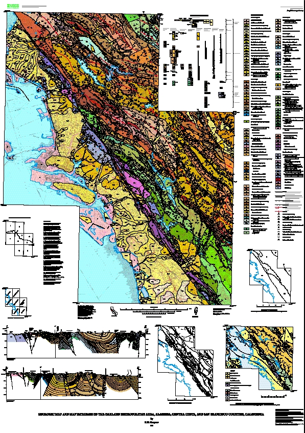
This database and accompanying plot files depict the distribution of geologic materials and structures at a regional (1:24,000) scale. The report is intended to provide geologic information for the regional study of materials properties, earthquake shaking, landslide potential, mineral hazards, seismic velocity, and earthquake faults. In addition, the report contains new information and interpretations about the regional geologic history and framework. However, the regional scale of this report does not provide sufficient detail for site development purposes. In addition, this map does not take the place of fault-rupture hazard zones designated by the California State Geologist (Hart and Bryant, 1997). Similarly, the database cannot be used to identify or delineate landslides in the region.
Online Links:
Online Links:
Online Links:
Online Links:
Online Links:
Online Links:
Online Links:
Online Links:
Are there legal restrictions on access or use of the data?Access_Constraints: None
Use_Constraints:Uses of this digital geologic map should not violate the spatial resolution of the data. Although the digital form of the data removes the constraint imposed by the scale of a paper map, the detail and accuracy inherent in map scale are also present in the digital data. The fact that this database was edited for a scale of 1:24,000 means that higher resolution information is not present in the dataset. Plotting at scales larger than 1:24,000 will not yield greater real detail, although it may reveal fine-scale irregularities below the intended resolution of the database. Similarly, where this database is used in combination with other data of higher resolution, the resolution of the combined output will be limited by the lower resolution of these data.
Any use of trade, product, or firm names is for descriptive purposes only and does not imply endorsement by the U.S. Government. Although this publication has been subjected to rigorous review and is substantially complete, the USGS reserves the right to revise the data pursuant to further analysis and review. Furthermore, it is released on condition that neither the USGS nor the United States Government may be held liable for any damages resulting from its authorized or unauthorized use.
| Data format: | Printable map files in format EPSF (version 1.2) |
|---|---|
| Network links: |
http://pubs.usgs.gov/mf/2000/2342/mf2342a.tgz |
| Data format: | Printable map files in format PDF (version 3.0) |
|---|---|
| Network links: |
http://pubs.usgs.gov/mf/2000/2342/mf2342b.tgz |
| Data format: | Geologic units and structural features, with base map information in format Digital ARCE (version 7.2.1) |
|---|---|
| Network links: |
http://pubs.usgs.gov/mf/2000/2342/mf2342c.tgz |