Geologic map of the Frisco quadrangle, Summit County, Colorado

Metadata also available as - [Outline] - [Parseable text] - [XML]

Frequently anticipated questions:


What does this data set describe?

Title: Geologic map of the Frisco quadrangle, Summit County, Colorado
Abstract:
New 1:24,000-scale geologic mapping along the Interstate-70 urban corridor in western Colorado, in support of the USGS Central Region State/USGS Cooperative Geologic Mapping Project, is contributing to a more complete understanding of the stratigraphy, structure, tectonic evolution, and hazard potential of this rapidly developing region. The 1:24,000-scale Frisco quadrangle is near the headwaters of the Blue River and straddles features of the Blue River graben (Kellogg, K.S., 1999, Neogene basins of the northern Rio Grande rift—partitioning and asymmetry inherited from Laramide and older uplifts: Tectonophysics, v. 305, p. 141-152.), part of the northernmost reaches of the Rio Grande rift, a major late Oligocene to recent zone of extension that extends from Colorado to Mexico. The Williams Range thrust fault, the western structural margin of the Colorado Front Range, cuts the northeastern corner of the quadrangle.
The oldest rocks in the quadrangle underlie the Tenmile Range and include biotite-sillimanite schist and gneiss, amphibolite, and migmatite that are intruded by granite inferred to be part of the 1,667-1,750 Ma Routt Plutonic Suite (Tweto, Ogden, 1987, Rock units of the Precambrian- basement in Colorado: U.S. Geological Survey Professional Paper 1321-A, 54 p.). The oldest sedimentary unit is the Pennsylvanian Maroon Formation, a sequence of red sandstone, conglomerate, and interbedded shale. The thickest sequence of sedimentary rocks is Cretaceous in age and includes at least 500 m of the Upper Cretaceous Pierre Shale. The sedimentary rocks are intruded by sills and dikes of dacite porphyry sills of Swan Mountain, dated at 44 Ma (Marvin, R.F., Mehnert, H.H., Naeser, C.W., and Zartman, R.E., 1989, U.S. Geological Survey radiometric ages, compilation “C”—Part five—Colorado, Montana, Utah, and Wyoming: Isochron/West, no. 53, p. 14-19. Simmons, E.C., and Hedge, C.E., 1978, Minor-element and Sr-isotope geochemistry of Tertiary stocks, Colorado mineral belt: Contributions to Mineralogy and Petrology, v. 67, p. 379-396.). Surficial deposits include (1) an old, deeply dissected landslide deposit, possibly as old as Tertiary, on the south flank of Tenderfoot Mountain, (2) deeply weathered, very coarse gravel deposits, mostly along Gold Run and underlying Mesa Cortina; the gravels are gold bearing and were mined by hydraulic methods in the 1800's, (3) glacial deposits of both Bull Lake (middle Pleistocene) and Pinedale (late Pleistocene) that were derived from large valley glaciers that flowed down Tenmile and North Tenmile Creeks; the town of Frisco is underlain mostly by Pinedale-age glacial outwash, (4) recent landslide deposits, including one large (about 1 square kilometer) area just downslope from Lilly Pad Lake, west of I-70, and (5)extensive colluvial and alluvial deposits.
The latest seismic events appear to be middle Pliestocene in age and are associated with small scarps that cut Bull Lake till but do not cut Pinedale till.
Supplemental_Information:
Compilation scale: 1:24,000
Geology mapped in 1997 and 1998.
  1. How might this data set be cited?
    Kellogg, Karl S., Bartos, Paul, J., and Williams, Cindy L., 2002, Geologic map of the Frisco quadrangle, Summit County, Colorado: U.S. Geological Survey Miscellaneous Field Studies Map MF-2340, U.S. Geological Survey, Denver, Colorado.

    Online Links:

  2. What geographic area does the data set cover?
    West_Bounding_Coordinate: -106.125
    East_Bounding_Coordinate: -106.0
    North_Bounding_Coordinate: 39.612
    South_Bounding_Coordinate: 39.50
  3. What does it look like?
    http://pubs.usgs.gov/mf/2002/mf-2340/mf-2340.gif (GIF)
    Reduced-size image of the entire map sheet; 288x277 pixels, 42k bytes.
    http://pubs.usgs.gov/mf/2002/mf-2340/mf-2340.pdf (PDF)
    Printable representation of map layout; includes correlation, cross sections, list of map units, and index maps, 3.6 megabytes.
  4. Does the data set describe conditions during a particular time period?
    Calendar_Date: 2000
    Currentness_Reference:
    publication date
  5. What is the general form of this data set?
  6. How does the data set represent geographic features?
    1. How are geographic features stored in the data set?
      This is a Vector data set.
    2. What coordinate system is used to represent geographic features?
      The map projection used is Polyconic.
      Projection parameters:
      Longitude_of_Central_Meridian: -105.5
      Latitude_of_Projection_Origin: 38.45
      False_Easting: 0.000
      False_Northing: 0.000
      Planar coordinates are encoded using coordinate pair
      Abscissae (x-coordinates) are specified to the nearest 20
      Ordinates (y-coordinates) are specified to the nearest 20
      Planar coordinates are specified in METERS
      The horizontal datum used is North American Datum of 1927.
      The ellipsoid used is Clarke 1866.
      The semi-major axis of the ellipsoid used is 6378206.4.
      The flattening of the ellipsoid used is 1/294.98.
  7. How does the data set describe geographic features?
    Entity_and_Attribute_Overview:
    The data is supplied in ARC/INFO export and shape file formats.
    DATABASE STRUCTURE - ARC/INFO ====================================
    The database of the map consists of coverages, including corresponding INFO files:
    friscopoly2 coverage: Contains all contact lines and labelpoints for each polygon. In the coverage's friscopoly2.aat INFO file the CODE item provides a numeric code that specifies the geologic identity and positional quality of each contact line (e.g., fault, approximately located), and the P1 and P2 items are relic cartographic parameters from the GSMCAD compilation program. The friscopoly2.aat CODE values are defined below. In the friscopoly2.pat INFO file the CODE and P2 items are relic cartographic parameters from the GSMCAD program, the P1 item provides a numeric code that specifies the polygon's map unit identity, the TEXT item indicates the map unit label for each polygon, and the SYMBOL item defines the polygon color as chosen from the color524.shd shadeset (included in bundled file archive). The friscopoly2.pat P1 and TEXT items are listed below.
    friscoline2 coverage: Contains faults, fold axes, and other non-contact lines. Faults that are contacts also appear in the friscopoly2 coverage. In the friscoline2.aat INFO file the CODE item provides a numeric code that specifies the geologic identity and positional quality for each type of line, the P1 and P2 items are relic cartographic parameters from the GSMCAD program, and the TEXT item describes the geologic identity, positional quality, and, in some cases, additional aspects of each line. The friscoline2.aat CODE and TEXT items are listed below.
    friscopoint2 coverage: Contains points used for cartographically decorating lines, such as "ball-and-bar" fault symbols, and teeth on thrust faults. In the INFO file friscopoint2.pat the CODE item defines a numeric code for each type of point decoration and the P1 and P2 items indicate the orientation (or strike azimuth) and, where appropriate, dip (or plunge) value associated with each point symbol. The friscopoint2.pat CODE items are listed below.
    Auxiliary files:
    color524.shd: This shadeset file defines the rgb values of colors assigned to polygons in the friscopoly2 coverage (see SYMBOL item).
    Readme.doc: Disclaimer and list of included files.
    Map unit labels listed here with associated numeric codes. Unit names and fuller descriptions of the units are in the explanatory pamphlet accompanying the map and data files.
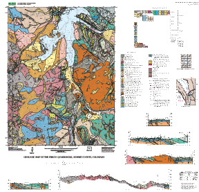
    P1  | GEOLOGIC MAP UNIT LABELS
    205 | af
    207 | dt
    148 | Qal
    165 | Qs
    164 | Qav
    163 | Qry
    161 | Qr
    176 | Qtr
    147 | Qf
    162 | Qt
    101 | Qc
    100 | Qac
    155 | Qls
    152 | Qg
    206 | Qop
    200 | Qtp
    201 | Qtb
    204 | Qgo
    210 | Qgm
    202 | Qgg
    175 | Qd
    153 | QTls
    220 | Tqp
    233 | Kpm
    232 | Kps
    231 | Kpl
    240 | Kn
    242 | Kb
    106 | Kd
    104 | Jm
    105 | Je
    107 | TrPcm
    162 | Xu
    266 | Xgg
    264 | Xgd
    259 | Xmg
    263 | Xhpg
    250 | Xbg
    255 | YXp
    257 | Yxdi
    262 | YXu
    265 | Xum
    
    DEFINITION OF CODES IN THE DATABASE COVERAGES (CODES AND TEXT LISTED IN THE .AAT AND .PAT FILES)
    CODE |  TEXT (DEFINITION)
      1  | contact; certain
      2  | contact; approximately located
      3  | contact; concealed
     11  | fault; certain
     12  | fault; approximately located
     13  | fault; concealed
     21  | normal fault; certain
     22  | normal fault; approximately located
     23  | normal fault; concealed
     31  | thrust fault; certain; upthrown on right side
     32  | thrust fault; approximate location; upthrown on right side
     33  | thrust fault; concealed; upthrown on right side
     41  | reverse fault; certain
     42  | reverse fault; approximately located
     43  | reverse fault; concealed
     51  | syncline axis; certain
     52  | syncline axis; concealed
     61  | anticline axis; certain
     62  | anticline axis; concealed
     65  | strike-slip arrows
     71  | dike or sill
     72  | quartz vein
     93  | water boundary
     94  | scratch contact
     95  | cross-section line
     99  | map boundary
    200  | plunge arrow
    201  | bedding attitude (P1=strike azimuth 90 deg.CCW from dip direction, P2=dip angle)
    202  | strike and dip foliation symbol
    203  | plunge and bearing (lineation)symbol
    204  | anticline arrows(P1=orientation azimuth)
    205  | syncline arrows(P1=orientation azimuth)
    207  | bar and ball symbol(P1=orientation azimuth)
    208  | dip symbol on contact or fault (P1=strike azimuth, P2=dip angle)
    209  | left-lateral arrows (P1=orientation azimuth)
    210  | right-lateral arrows(P1=orientation azimuth)
    213  | strike and dip of joints symbol (P1=strike azimuth 90 deg.CCW from dip direction, P2=dip angle)
    217  | fold plunge arrow symbol(P1=orientation azimuth)
    219  | strike and dip of overturned beds symbol(P1=strike azimuth 90 deg.CCW from dip direction, P2=dip angle)
    220  | strike and dip, approximate (P1=strike azimuth 90 deg.CCW from dip direction, P2=dip angle)
    221  | vertical bed symbol(P1=orientation azimuth)
    222  | vertical foliation symbol(P1=orientation azimuth)
    230  | vertical joint symbol(P1=orientation azimuth)
    246  | strike with undetermined dip symbol(P1=strike azimuth 90 deg.CCW from dip direction, P2=dip angle)
    251  | strike and dip of foliation symbol(P1=strike azimuth 90 deg.CCW from dip direction, P2=dip angle)
    500  | Unit labels text & tag
    501  | Hidden unit tags
    502  | rock text
    510  | ordinary text
    701  | Splined text
    
    Entity_and_Attribute_Detail_Citation: http://pubs.usgs.gov/mf/2002/mf-2340/mf-2340pam.pdf

Who produced the data set?

  1. Who are the originators of the data set? (may include formal authors, digital compilers, and editors)
    • Kellogg, Karl S.
    • Bartos, Paul, J.
    • Williams, Cindy L.
  2. Who also contributed to the data set?
    A.M. Licamelli, R.G. Kuehn, K.S. Morgan
  3. To whom should users address questions about the data?
    Karl Kellogg
    U.S. Geological Survey, CR
    Mail Stop 913
    Box 25046, Denver Federal Center
    Denver, CO
    USA

    303-236-1305 (voice)
    303-236-0214 (FAX)
    kkellogg@usgs.gov

Why was the data set created?

To update and reinterpret earlier geologic mapping, and to achieve a uniform regional geologic database.

How was the data set created?

  1. From what previous works were the data drawn?
    Kellogg and others (2002) (source 1 of 1)
    Kellogg, Karl, Bartos, Paul, and Williams, Cindy, (unpublished), unpublished mapping done in 1997 and 1998.

    Type_of_Source_Media: greenline mylar topographic base map
    Source_Contribution: This data was used to compile the geologic map.
  2. How were the data generated, processed, and modified?
    Date: 2002 (process 1 of 2)
    The Frisco geologic database was compiled using the GSMCAD public domain program (USGS Open-File Report 96-007 ). It was exported to ARC/INFO using the GSMCAD export function to create ARC generate ASCII files and the gsmarc.aml program in ARC was used to convert the ASCII files to ARC coverages and build polygons. The compilation was completed November, 1999. The review and revision was completed April, 2000. Archive files prepared June 2002.
    Date: 09-Jul-2009 (process 2 of 2)
    Creation of original metadata record Person who carried out this activity:
    Karl S. Kellogg
    U.S. Geological Survey
    MS 913, Box 25046 DFC
    Lakewood, CO

    303-236-1305 (voice)
  3. What similar or related data should the user be aware of?

How reliable are the data; what problems remain in the data set?

  1. How well have the observations been checked?
    Data was entered and checked by the geologist who made the observations. The attributes of this geospatial data set consist of text identifiers and numeric codes that indicate the identity of the geologic unit or type of geologic feature, and determine how each feature is colored or symbolized. To check attribute accuracy, a color check plot was visually compared to the geologist's original compilation. Discrepancies between the digital geospatial dataset and the original analog compilation were corrected as needed. Machine-created listings of unique attribute values were used to identify spelling errors or other inconsistencies, and corrections were made as needed. This map has been thoroughly reviewed for conformity with U.S. Geological Survey editorial standards and stratigraphic nomenclature.
  2. How accurate are the geographic locations?
    Lines were primarily mapped by ground investigation and photo-interpretation of 1:24,000-scale color aerial photographs. These lines were digitized from the topographic field sheets and from annotated aerial photographs. Most digitized positions on the map are estimated to have about 20 m horizontal accuracy. Additional point observations were added using positions determined by a Rockwell PLGR-96 GPS unit with horizontal accuracy of about 10 m. There is no elevation data in the database.
  3. How accurate are the heights or depths?
  4. Where are the gaps in the data? What is missing?
    Data is complete: no features were eliminated or generalized. Unit properties are described in the text explanation. A digital base map coverage is not included but is available separately.
  5. How consistent are the relationships among the observations, including topology?
    Map elements were visually checked by the author for overshoots, undershoots, duplicate features, polygon attributes, and other errors. Automated (ARC/INFO) routines were also used to check the databases for polygon label errors, line or point attribution errors, sliver polygons, dangling arcs, intersection errors, and projection information. The map was reviewed by two other geologists for consistency with basic geologic principles and general conformity to USGS mapping standards.

How can someone get a copy of the data set?

Are there legal restrictions on access or use of the data?
Access_Constraints: none
Use_Constraints:
none. Acknowledgment of the U.S. Geological Survey would be appreciated in products derived from these data.
  1. Who distributes the data set? (Distributor 1 of 1)
    U.S. Geological Survey Information Services
    Box 25286 Denver Federal Center
    Denver, CO
    United States

    1-888-ASK-USGS (voice)
  2. What's the catalog number I need to order this data set?
  3. What legal disclaimers am I supposed to read?
    Although this digital spatial data has been subjected to rigorous review and is substantially complete, it is released on the condition that neither the USGS nor the United States Government may be held liable for any damages resulting from its authorized or unauthorized use.
  4. How can I download or order the data?

Who wrote the metadata?

Dates:
Last modified: 10-Jun-2016
Metadata author:
Peter N Schweitzer
USGS Midwest Area
Collection manager, USGS Geoscience Data Clearinghouse, http://geo-nsdi.er.usgs.gov/
Mail Stop 954
12201 Sunrise Valley Dr
Reston, VA
USA

703-648-6533 (voice)
703-648-6252 (FAX)
pschweitzer@usgs.gov
Metadata standard:
Content Standard for Digital Geospatial Metadata (FGDC-STD-001-1998)

This page is <https://geo-nsdi.er.usgs.gov/metadata/map-mf/2340/metadata.faq.html>
Generated by mp version 2.9.48 on Tue Jul 03 20:05:02 2018