Online Links:
| Value | Definition |
|---|---|
| CZw | Wood Canyon Formation |
| Cb | Bonanza King Formation |
| Cc | Carrara Formation |
| Cn | Nopah Formation |
| Cz | Zabriskie Quartzite |
| DSd | Dolomite |
| Dc | Dolomite limestone and sandy dolomite |
| MDs | Clastic sedimentary rocks (includes Eleana) |
| Mc | Chainman Shale |
| Ou | Sedimentary rocks, undivided (Ely Sprs. Eureka Pogonip) |
| Qa | Alluvium (Holocene) |
| Qam | Alluvium (late and middle Pleistocene) |
| Qao | Older alluvium (middle and early Pleistocene) |
| Qay | Younger alluvium (Holocene and late Pleistocene) |
| Qay/Qam | mantle of Qay over Qam |
| Qay/Qem | mantle of Qay over Qem |
| Qbo | Older Quaternary basalt |
| Qby | Younger Quaternary basalt |
| Qe | Eolian deposits (Holocene to middle Pleistocene) |
| Qem | Eolian-colluvial ramp deposits (Holocene-middle Pleis.) |
| Qem/Qao | mantle of Qem over Qao |
| Qeo | Older eolian sand (middle to early Pleistocene) |
| Qey | Eolian sand and fragments (Holocene and late Pleistocene) |
| Qey/Qam | mantle of Qey over Qam |
| Qey/Qeo | mantle of Qey over Qeo |
| Qsd | Spring deposits (Holocene to middle Pleistocene) |
| Tac | Calico Hills Formation |
| Tbo | Older Tertiary basalts (Miocene) |
| Tby | Younger Tertiary basalt of Crater Flat (Pliocene) |
| Tcb | Bullfrog Tuff |
| Tcp | Prow Pass Tuff |
| Tcr | Rhyolite of Prospector Pass |
| Tcs | Pre-Bullfrog Tuff bedded tuff |
| Tct | Tram Tuff |
| Tfb | Beatty Wash Formation |
| Tfd | Lavas of Dome Mountain |
| Tfs | Rhyolite of Shoshone Mountain |
| Tgc | Conglomerates, fanglomerates, and rock-avalanche breccia |
| Ti | Intrusions (Miocene) |
| Tma | Ammonia Tanks Tuff |
| Tmb | Rhyolite of Waterpipe Butte |
| Tmp | Rhyolite of Pinnacles Ridge |
| Tmr | Rainier Mesa Tuff |
| Tmw | Rhyolite of Windy Wash |
| Tpbt | Bedded tuff (Paintbrush Gp.) |
| Tpc | Tiva Canyon Tuff |
| Tpcy | Tuff of Pinyon Pass |
| Tpd | Rhyolite of Delirium Canyon |
| Tpk | Rhyolite of Comb Peak |
| Tpp | Pah Canyon Tuff |
| Tpr | Rhyolite lavas, undivided (Paintbrush Gp.) |
| Tpt | Topopah Spring Tuff |
| Tpv | Rhyolite of Vent Pass |
| Tpx | Paintbrush Group tuffs, undivided (flt zn: tectonically mixed) |
| Tpy | Yucca Mountain Tuff |
| Trx | Rock-avalanche breccia of southern Crater Flat (Miocene) |
| Ts | Older sedimentary rocks, undivided (Miocene and Oligocene |
| Ttr | Rocket Wash Tuff of Thirsty Canyon Group (Miocene) |
| Tvo | Older volcanic rocks, undivided (Miocene) |
| Tvx | Intracaldera and caldera margin megabreccia and mesobreccia |
| Tvy | Younger volcanic rocks (Pliocene to Miocene) |
| Tw | Wahmonie Formation |
| Zs | Stirling Quartzite |
| Range of values | |
|---|---|
| Minimum: | 0 |
| Maximum: | 999 |
| Value | Definition |
|---|---|
| BORDER_50K_MAP | Extent of study area |
| CALDERA | Structural Boundary of Claim Canyon Caldera |
| CONTACT | Geologic contact - exposed or well constrained |
| CONTACT_APPROX | Geologic contact - approximately located |
| CONTACT_CONCEALED | Geologic contact - concealed beneath Quaternary cover or poorly exposed |
| CONTACT_Q | Geologic contact of Quaternary aged deposits |
| CROSS_SECTION_LINES | Location of cross sections A-A', B-B', C-C', and D-D' |
| FAULT | Fault - exposed or well constrained |
| FAULT_APPROX | Fault - approximately located |
| FAULT_INFER_GEOL | Fault - concealed and inferred beneath Quaternary cover |
| FAULT_INFER_GP | Fault - concealed beneath Quaternary cover and inferred from geophysical data |
| FAULT_PRE_TERTIARY_THRUST | Thrust fault - pre-Tertiary age, exposed or well constrained |
| FAULT_PRE_TERTIARY_THRUST_INFER | Thrust fault - pre-Tertiary age, concealed and inferred beneath Quaternary cover or poorly exposed |
| FAULT_LOW_ANGLE_NORMAL | Gently dipping normal fault |
| SCARP_AL | Fault scarps in Quaternary deposits |
| SYMBOL_CALC_DIP | Symbols displaying strike and dip of bedrock estimated using 3-point method |
| SYMBOL_FLT_FLD | Symbols displaying relative horizontal movement (paired arrows) on faults, teeth on reverse faults, and queries (uncertain) fault locations), and fold axes |
| SYMBOL_FOLIATION | Symbols displaying strike and dip of compaction foliation |
| SYMBOL_HORIZ_BD | Symbols displaying horizontal bedding |
| SYMBOL_OVRTRN_BD | Symbols displaying overturned bedding |
| SYMBOL_STRIKE_DIP | Symbols displaying strike and dip of bedding |
| SYMBOL_VERT_BED | Symbols displaying vertically dipping bedding |
| UNIT_LABELS | Line leaders from map unit to text describing bedrock geologic units |
| UNIT_LABELS_Q | Line leaders from map unit to text describing geologic units of Quaternary age |
COLUMN--ITEM_NAME----------WIDTH-----OUTPUT-----TYPE---#_DECIMALS
1-------FNODE#---------------4----------5---------B---------\
5-------TNODE#---------------4----------5---------B---------\
9-------LPOLY#---------------4----------5---------B---------\
13------RPOLY#---------------4----------5---------B---------\
17------LENGTH---------------8---------18---------F---------5
25------<cover>#-------------4----------5---------B---------\
29------<cover>-ID-----------4----------5---------B---------\

For polygons these attributes are:

COLUMN--ITEM_NAME----------WIDTH-----OUTPUT-----TYPE---#_DECIMALS
1-------AREA-----------------8---------18---------F---------5
9-------PERIMETER------------8---------18---------F---------5
17------<cover>#-------------4----------5---------B---------\
21------<cover>-ID-----------4----------5---------B---------\

COVERAGE-----FEATURE-----DESCRIPTION
Items/Attributes----------Values

plate1-----lines-----cultural linework  (roads, township and range, NTS boundary, map border and tics)

ITEM: layer          DESCRIPTION:
ROADS_FINAL          Roads in study area
TOWN_RANGE           Township and range boundaries
SECTIONS_100K        Township and range section lines
NTS                  Nevada Test Site boundary
BORDER               Map border
TICS_STATE_PLANE     Nevada State Plane graticules
TICS_LAT_LONG        Latitude and longitude graticules

ball_bar-----lines--------displacement symbols on faults
ball_bar-----polygons-----displacement symbols on faults
ITEM: ssym          DESCRIPTION:
1                   Number corresponding to a shadeset symbol

szgeol-----polygons-------geologic units
ITEMS:              DESCRIPTION:
MAP_UNIT            Lithostratigraphic symbols
UNIT_DESCRIPTION    Description of lithostratigraphic symbols
SSYM                Number corresponding to a shadeset symbol
(Values for the coverage items are presented in table format below)

MAP_UNIT...UNIT_DESCRIPTION...                                        SSYM
CZw        Wood Canyon Formation                                       694
Cb         Bonanza King Formation                                      461
Cc         Carrara Formation                                           601
Cn         Nopah Formation                                             518
Cz         Zabriskie Quartzite                                         810
DSd        Dolomite                                                     55
Dc         Dolomite limestone and sandy dolomite                        52
MDs        Clastic sedimentary rocks (includes Eleana)                 332
Mc         Chainman Shale                                              179
Ou         Sedimentary rocks, undivided (Ely Sprs. Eureka Pogonip)     238
Qa         Alluvium (Holocene)                                         748
Qam        Alluvium (late and middle Pleistocene)                      705
Qao        Older alluvium (middle and early Pleistocene)               501
Qay        Younger alluvium (Holocene and late Pleistocene)            575
Qay/Qam    mantle of Qay over Qam                                      705
Qay/Qem    mantle of Qay over Qem                                      767
Qbo        Older Quaternary basalt                                      98
Qby        Younger Quaternary basalt                                   130
Qe         Eolian deposits (Holocene to middle Pleistocene)            759
Qem        Eolian-colluvial ramp deposits (Holocene-middle Pleis.)     767
Qem/Qao    mantle of Qem over Qao                                      501
Qeo        Older eolian sand (middle to early Pleistocene)             576
Qey        Eolian sand and fragments (Holocene and late Pleistocene)   715
Qey/Qam    mantle of Qey over Qam                                      705
Qey/Qeo    mantle of Qey over Qeo                                      576
Qsd        Spring deposits (Holocene to middle Pleistocene)            681
Tac        Calico Hills Formation                                      184
Tbo        Older Tertiary basalts (Miocene)                            129
Tby        Younger Tertiary basalt of Crater Flat (Pliocene)           372
Tcb        Bullfrog Tuff                                               509
Tcp        Prow Pass Tuff                                              422
Tcr        Rhyolite of Prospector Pass                                 151
Tcs        Pre-Bullfrog Tuff bedded tuff                               322
Tct        Tram Tuff                                                   152
Tfb        Beatty Wash Formation                                       632
Tfd        Lavas of Dome Mountain                                      119
Tfs        Rhyolite of Shoshone Mountain                               633
Tgc        Conglomerates, fanglomerates, and rock-avalanche breccia    652
Ti         Intrusions (Miocene)                                        217
Tma        Ammonia Tanks Tuff                                          721
Tmb        Rhyolite of Waterpipe Butte                                 111
Tmp        Rhyolite of Pinnacles Ridge                                 707
Tmr        Rainier Mesa Tuff                                           124
Tmw        Rhyolite of Windy Wash                                      905
Tpbt       Bedded tuff (Paintbrush Gp.)                                116
Tpc        Tiva Canyon Tuff                                            901
Tpcy       Tuff of Pinyon Pass                                         732
Tpd        Rhyolite of Delirium Canyon                                 114
Tpk        Rhyolite of Comb Peak                                       154
Tpp        Pah Canyon Tuff                                             542
Tpr        Rhyolite lavas, undivided (Paintbrush Gp.)                  155
Tpt        Topopah Spring Tuff                                         336
Tpv        Rhyolite of Vent Pass                                       554
Tpx        Paintbrush Group tuffs, undivided (flt zn: tectonically mixed) 577
Tpy        Yucca Mountain Tuff                                         514
Trx        Rock-avalanche breccia of southern Crater Flat (Miocene)    303
Ts         Older sedimentary rocks, undivided (Miocene and Oligocene   387
Ttr        Rocket Wash Tuff of Thirsty Canyon Group (Miocene)          555
Tvo        Older volcanic rocks, undivided (Miocene)                   909
Tvx        Intracaldera and caldera margin megabreccia and mesobreccia 541
Tvy        Younger volcanic rocks (Pliocene to Miocene)                527
Tw         Wahmonie Formation                                          304
Zs         Stirling Quartzite                                          494

szlines-----lines-----attributed with ITEM layer as follows:
ITEM: layer                        DESCRIPTION:
BORDER_50K_MAP                     Extent of study area
CALDERA                            Structural Boundary of Claim Canyon Caldera
CONTACT                            Geologic contact - exposed or well constrained
CONTACT_APPROX                     Geologic contact - approximately located
CONTACT_CONCEALED                  Geologic contact - concealed beneath Quaternary cover or poorly exposed
CONTACT_Q                          Geologic contact of Quaternary aged deposits
CROSS_SECTION_LINES                Location of cross sections A-A', B-B', C-C', and D-D'
FAULT                              Fault - exposed or well constrained
FAULT_APPROX                       Fault - approximately located
FAULT_INFER_GEOL                   Fault - concealed and inferred beneath Quaternary cover
FAULT_INFER_GP                     Fault - concealed beneath Quaternary cover and inferred from geophysical data
FAULT_PRE_TERTIARY_THRUST          Thrust fault - pre-Tertiary age, exposed or well constrained
FAULT_PRE_TERTIARY_THRUST_INFER    Thrust fault - pre-Tertiary age, concealed and inferred beneath Quaternary cover or poorly exposed
FAULT_LOW_ANGLE_NORMAL             Gently dipping normal fault
SCARP_AL                           Fault scarps in Quaternary deposits
SYMBOL_CALC_DIP                    Symbols displaying strike and dip of bedrock estimated using 3-point method
SYMBOL_FLT_FLD                     Symbols displaying relative horizontal movement (paired arrows) on faults, teeth on reverse faults, and queries (uncertain) fault locations), and fold axes
SYMBOL_FOLIATION                   Symbols displaying strike and dip of compaction foliation
SYMBOL_HORIZ_BD                    Symbols displaying horizontal bedding
SYMBOL_OVRTRN_BD                   Symbols displaying overturned bedding
SYMBOL_STRIKE_DIP                  Symbols displaying strike and dip of bedding
SYMBOL_VERT_BED                    Symbols displaying vertically dipping bedding
UNIT_LABELS                        Line leaders from map unit to text describing bedrock geologic units
UNIT_LABELS_Q                      Line leaders from map unit to text describing geologic units of Quaternary age

szlines-----annotation-----Text for geologic units, borehole and map symbol labels
subclass:    anno.dxf    Description
Level
1                        geology labels
3                        fault names
4                        cross section trace labels
5                        borehole labels
6                        foliation labels
7                        measured strike and dip labels
8                        calculated strike and dip labels
9                        overturned bedding labels
10                       queries symbols(?)on fault traces

szlines-----points-----borehole locations
ITEM: layer              DESCRIPTION:
BOREHOLES_1996           Location of selected bore holes in study area

Topo24k_pot-----arcs-----topographic base
ITEMS:                   DESCRIPTION:
elev_ft                  elevation of line
index200                 1 if line is a 200 ft index contour, otherwise 0
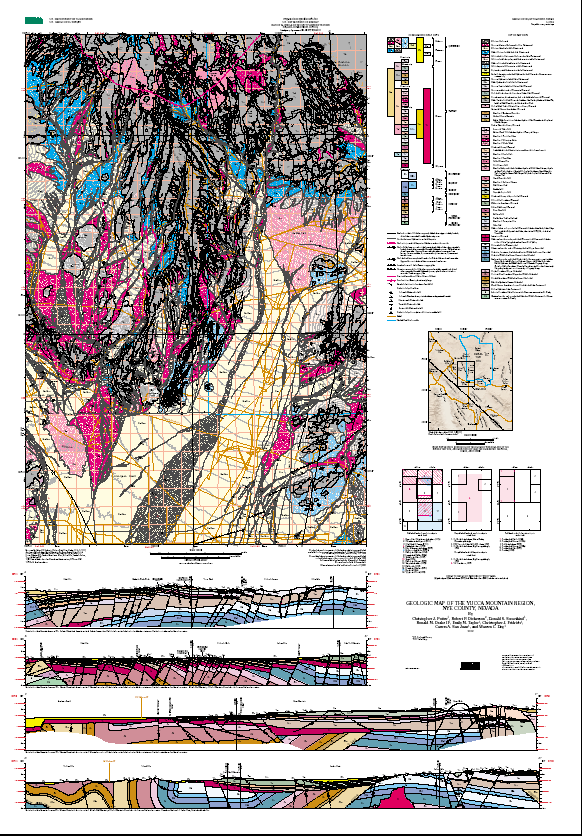
Bedrock geology mapped by Christopher J. Potter, Robert P. Dickerson, Donald S. Sweetkind, Ronald M. Drake II, Christopher J. Fridrich, and Warren C. Day, 1997-1998, and compiled from data sources cited below. Surficial geology mapped by Emily M. Taylor in 1998, and compiled from data sources cited below. Geologic contacts and faults digitized by Ronald M. Drake II, Carma A. San Juan, and Emily M. Taylor.
This geologic map was constructed to provide the structural and stratigraphic framework for a saturated-zone groundwater model for the Yucca Mountain Project site area.
Are there legal restrictions on access or use of the data?Access_Constraints: None
Use_Constraints:Acknowledgment of the U.S. Geological Survey would be appreciated in products derived from these data.
Although these digital spatial data have been subjected to rigorous review and are substantially complete, they are released on the condition that neither the USGS nor the United States Government may be held liable for any damages resulting from their authorized or unauthorized use.
| Data format: | Geologic units and structural features in format ARCE (version 8.0.2) Size: 7 |
|---|---|
| Network links: |
http://pubs.usgs.gov/imap/i-2755/i-2755.tar.gz http://pubs.usgs.gov/imap/i-2755/i-2755.zip |