Geologic and aeromagnetic maps of the Fossil Ridge area and vicinity, Gunnison County, Colorado

Metadata also available as - [Outline] - [Parseable text] - [XML]

Frequently anticipated questions:


What does this data set describe?

Title:
Geologic and aeromagnetic maps of the Fossil Ridge area and vicinity, Gunnison County, Colorado
Abstract:
This data set includes a GIS geologic map database of an Early Proterozoic metavolcanic and metasedimentary terrane extensively intruded by Early and Middle Proterozoic granitic plutons. Laramide to Tertiary deformation and intrusion of felsic plutons have created numerous small mineral deposits that are described in the tables and are shown on the figures in the accompanying text pamphlet. Also included in the pamphlet are numerous chemical analyses of igneous and meta- igneous bodies of all ages in tables and in summary geochemical diagrams. The text pamphlet also contains a detailed description of map units and discussions of the aeromagnetic survey, igneous and metmorphic rocks, and mineral deposits. The printed map sheet and browse graphic pdf file include the aeromagnetic map of the study area, as well as figures and photographs.
Supplemental_Information:
Files:
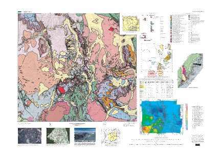
geo_poly.e00    stratigraphic contacts and geologic units
geo_line.e00    structural features such as dikes and faults
geo_pnt.e00     structural orientations, and sample localities
neatline.e00    neatline border for map
graphics.e00    graphic representations of point symbols
rfossil1112.tif Topographic base map image
rfossil1112.tfw Topographic image georeference information
  1. How might this data set be cited?
    DeWitt, Ed, Zech, R.S., Chase, C.G., Zartman, R.E., Kucks, R.P., Bartelson, Bruce, Rosenlund, G.C., and Early, III, Drummond, 2002, Geologic and aeromagnetic maps of the Fossil Ridge area and vicinity, Gunnison County, Colorado: U.S. Geological Survey Geologic Investigations Series I-2738.

    Online Links:

  2. What geographic area does the data set cover?
    West_Bounding_Coordinate: -106.75
    East_Bounding_Coordinate: -106.46
    North_Bounding_Coordinate: 38.79
    South_Bounding_Coordinate: 38.59
  3. What does it look like?
    http://pubs.usgs.gov/imap/i-2738/i-2738.gif (GIF)
    Reduced-size image of the map sheet, 432x307 pixels, 61k bytes
    http://pubs.usgs.gov/imap/i-2738/i-2738.pdf (PDF)
    Browse graphic shows the geologic map, aeromagnetic map, correlation of map units, description of map units, tabular data, figures showing mineral deposits, color photographs, and index map, 10 megabytes
  4. Does the data set describe conditions during a particular time period?
    Calendar_Date: 2002
    Currentness_Reference:
    publication date
  5. What is the general form of this data set?
    Geospatial_Data_Presentation_Form: vector digital data
  6. How does the data set represent geographic features?
    1. How are geographic features stored in the data set?
      This is a Vector data set.
    2. What coordinate system is used to represent geographic features?
      Grid_Coordinate_System_Name: Universal Transverse Mercator
      Universal_Transverse_Mercator:
      UTM_Zone_Number: 13
      Transverse_Mercator:
      Scale_Factor_at_Central_Meridian: 0.9996
      Longitude_of_Central_Meridian: -105
      Latitude_of_Projection_Origin: 0.0
      False_Easting: 500000
      False_Northing: 0.0
      Planar coordinates are encoded using coordinate pair
      Abscissae (x-coordinates) are specified to the nearest 100
      Ordinates (y-coordinates) are specified to the nearest 100
      Planar coordinates are specified in meters
  7. How does the data set describe geographic features?
    geo_polyp.dbf
    Geologic units
    NAME
    Symbol for the geologic unit (string of width 16)
    ValueDefinition
    QuAlluvial and glacial deposits, undivided (Holocene and Pleistocene)
    TsGravel and alluvial deposits (Pliocene and Miocene?)
    TrRhyolite dikes, sills, and stocks (Oligocene)
    TgmPorphyry of Green Mountain (Oligocene)
    TKtTonalite stock and sill at Cumberland Pass (early Tertiary to Late Cretaceous?)
    KfFossil Ridge Latite (Late Cretaceous)
    KuSedimentary rocks, undivided (Upper Cretaceous) (this value does not appear in the data)
    KdDakota Sandstone (Upper Cretaceous)
    JmMorrison Formation (Upper Jurassic) (this value does not appear in the data)
    JjJunction Creek Sandstone (Upper Jurassic)
    JmjMorrison Formation and Junction Creek Sandstone (Upper Jurassic)
    PgGothic Formation (Middle Pennsylvanian)
    PbBelden Formation (Middle Pennsylvanian)
    MlLeadville Limestone (Lower Mississippian)
    MDcChaffee Group (Lower Mississippian? and Upper Devonian)
    OfhFremont Limestone (Upper Ordovician) and Harding Sandstone (Middle Ordovician)
    OmManitou Dolomite (Lower Ordovician)
    OuFremont Limestone, Harding Sandstone, and Manitou Dolomite, undivided (Upper Ordovician to Lower Ordovician)
    CsSawatch Quartzite (Upper Cambrian)
    YgGranite (Middle(?) Proterozoic)
    YtGranite of Taylor River (Middle (?) Proterozoic)
    YXgbGabbro dikes (Middle to Early Proterozoic)
    XaGranodiorite at Almont (Early Proterozoic) (this value does not appear in the data)
    XfFairview Peak Granodiorite (Early Proterozoic)
    XmgMetagabbro near Almont (Early Proterozoic)
    XhHenry Mountain Granite (Early Proterozoic)
    XwWillow Monzonite (Early Proterozoic)
    XwgMonzogabbro (to gabbro-diorite) part of the Willow Monzonite (Early Proterozoic)
    XcCrystal Gabbro (Early Proterozoic)
    XbGranodiorite of Broncho Mountain (Early Proterozoic)
    XrRoosevelt Granite (Early Proterozoic)
    XsMetasedimentary rocks (Early Proterozoic)
    XgbMetagabbro (Early Proterozoic)
    XfvFelsic metavolcanic rocks (Early Proterozoic)
    XivIntermediate-composition metavolcanic and metasedimentary rocks (Early Proterozoic)
    XmvMafic metavolcanic rocks (Early Proterozoic)
    LAKEsurface water body
    geo_polyl.dbf
    Geologic contacts
    ACCURACY
    Author's general confidence in position of feature (string of width 16)
    ValueDefinition
    (no value) 
    approximate 
    certain 
    Certain 
    concealedposition inferred from other evidence(?)
    TYPE_L
    Role of arc in the map (string of width 20)
    ValueDefinition
    (no value) 
    colorboundary 
    contactseparates geologic units
    geo_line.dbf
    Linear and arcuate geologic features
    ID
    (integer)
    ValueDefinition
    0 
    FAULTTYPE
    General class of fault (string of width 16)
    ValueDefinition
    (no value)feature is not a fault
    Normal 
    Thrust Fault 
    ACCURACY
    Author's confidence in position of feature (string of width 16)
    ValueDefinition
    (no value) 
    Approximate 
    Certain 
    Concealed 
    Inferred 
    FOLDTYPE
    General class of fold (string of width 16)
    ValueDefinition
    (no value)feature is not a fold
    Anticline 
    Monocline 
    Syncline 
    NAME
    Geologic unit in which feature occurs (?) (string of width 40)
    ValueDefinition
    (no value) 
    KfFossil Ridge Latite (Late Cretaceous)
    Kf?Fossil Ridge Latite (Late Cretaceous)
    TrRhyolite dikes, sills, and stocks (Oligocene)
    YXgbGabbro dikes (Middle to Early Proterozoic)
    TYPE
    General class of geologic feature (string of width 40)
    ValueDefinition
    Dike 
    Fault 
    Fold 
    quartz-bubnerite-molybdenite-veinlets 
    geo_pnt.dbf
    Orientation measurements
    ID
    (integer)
    ValueDefinition
    0 
    ANGLE
    (integer)
    Range of values
    Minimum:0
    Maximum:96
    Units:degrees
    Resolution:1
    TYPE
    General class of geologic surface whose orientation was measured (string of width 60)
    ValueDefinition
    bedding-inclined 
    bedding-overturned 
    foliation-inclined 
    foliation-vertical 
    igneous flow foliation-vertical 
    joint-inclined 
    joints-vertical 
    veinlet point 
    AZIMUTH
    (integer)
    Range of values
    Minimum:0
    Maximum:538
    Resolution:1

Who produced the data set?

  1. Who are the originators of the data set? (may include formal authors, digital compilers, and editors)
    • DeWitt, Ed
    • Zech, R.S.
    • Chase, C.G.
    • Zartman, R.E.
    • Kucks, R.P.
    • Bartelson, Bruce
    • Rosenlund, G.C.
    • Early, III, Drummond
  2. Who also contributed to the data set?
    Geology mapped by Ed DeWitt, R.S. Zech, C.G. Chase, Bruce Bartleson, C.G. Rosenlund, and Drummond Early III.
    Geochronology by Ed DeWitt and R.E. Zartman.
    Geophysics by R.A. Martin, Bob Kucks, and Ed DeWitt.
    The ArcInfo database was created by RedZone Software. ArcInfo database reviewed by Nancy Shock, who also prepared the ArcInfo files for importing into Illustrator. The Adobe Illustrator layout, which was used for the printed map and for the PDF browse graphic, was prepared by Gayle Dumonceaux. Metadata file prepared by F.C. Brunstein.
  3. To whom should users address questions about the data?
    U.S. Geological Survey
    Attn: DeWitt, Ed
    Geologist
    Minerals, MS 905 Denver Federal Center
    Denver, CO
    USA

    303-236-5636 (voice)

Why was the data set created?

This GIS geologic map database is provided to facilitate the presentation and analysis of earth-science data for this region of Colorado. This digital map database may be displayed at any scale or projection. However, the geologic data in this coverage are not intended for use at a scale other than 1:30, 000. Supplemental useful data accompanying the database are extensive geochemical and mineral deposits data, as well as an aeromagnetic map.

How was the data set created?

  1. From what previous works were the data drawn?
  2. How were the data generated, processed, and modified?
    Date: 2000 (process 1 of 2)
    This data was hand digitized in ArcInfo from a hand-drawn 1:30,000-scale stable base map.
    Date: 09-Oct-2003 (process 2 of 2)
    Creation of original metadata record Person who carried out this activity:
    U.S. Geological Survey, Geologic Division, Mineral Resource Surveys
    Attn: Ed DeWitt
    Minerals, MS 905, Box 25046, Denver Federal Center
    Denver, CO
    USA

    303-236-5636 (voice)
    edewitt@usgs.gov
  3. What similar or related data should the user be aware of?

How reliable are the data; what problems remain in the data set?

  1. How well have the observations been checked?
    The linework was captured by hand digitizing from a hand-drawn 1:30,000-scale stable base map. Vector and polygon attributes were obtained from a compilation of field maps. The digital data have been visually checked and the geologic map has undergone technical review.
  2. How accurate are the geographic locations?
    Users of this digital geologic map should respect the intentions of the original mappers and the limitations of the map. This geologic map is intended to be used at a scale of 1:30,000; it is not intended to be used at a more detailed scale.
  3. How accurate are the heights or depths?
  4. Where are the gaps in the data? What is missing?
    These digital files are the geospatial files used to create the geologic map. Files for the text, references, tables (chemical analyses, geochronology), and other figures are not included in the database files but are included in the browse graphics and printed copies of the map and pamphlet.
  5. How consistent are the relationships among the observations, including topology?
    This geology data set is a network coverage containing arcs and polygons. Each polygon has a coded attribute designating the mapped geologic unit. Faults and stratigraphic contacts are represented as arcs. When a fault is also a stratigraphic contact, only a single arc is present. Dangling arcs may be present (faults, dikes, etc.)

How can someone get a copy of the data set?

Are there legal restrictions on access or use of the data?
Access_Constraints: None
Use_Constraints: None
  1. Who distributes the data set? (Distributor 1 of 1)
    U.S. Geological Survey
    Box 25286, Building 810, Denver Federal Center
    Denver, CO
    USA

    1-888-ASK-USGS (voice)
  2. What's the catalog number I need to order this data set? USGS Geologic Investigations Series I-2738
  3. What legal disclaimers am I supposed to read?
    Any use of trade, product, or firm names is for descriptive purposes only and does not imply endorsement by the U.S. Government. Although this data has been used by the U.S. Geological Survey (USGS), no warranty, expressed or implied, is made by the USGS as to the accuracy of the data and related materials. The act of distribution shall not constitute any such warranty, and no responsibility is assumed by the USGS in the use of these data, software, or related materials.
  4. How can I download or order the data?

Who wrote the metadata?

Dates:
Last modified: 05-Feb-2016
Metadata author:
Peter N Schweitzer
USGS Midwest Area
Collection manager, USGS Geoscience Data Clearinghouse, http://geo-nsdi.er.usgs.gov/
Mail Stop 954
12201 Sunrise Valley Dr
Reston, VA
USA

703-648-6533 (voice)
703-648-6252 (FAX)
pschweitzer@usgs.gov
Metadata standard:
Content Standard for Digital Geospatial Metadata (FGDC-STD-001-1998)
Metadata extensions used:

This page is <https://geo-nsdi.er.usgs.gov/metadata/map-i/2738/metadata.faq.html>
Generated by mp version 2.9.48 on Tue Jul 03 20:04:54 2018