Geologic Map of the Central Marysvale Volcanic Field, Southwestern Utah

Metadata also available as - [Outline] - [Parseable text] - [XML]

Frequently anticipated questions:


What does this data set describe?

Title:
Geologic Map of the Central Marysvale Volcanic Field, Southwestern Utah
Abstract:
The geologic map of the central Marysvale volcanic field, southwestern Utah, shows the geology at 1:100,000 scale of the heart of one of the largest Cenozoic volcanic fields in the Western United States. The map shows the area of 38 degrees 15' to 38 degrees 42'30" N., and 112 degrees to 112 degrees 37'30" W. The Marysvale field occurs mostly in the High Plateaus, a subprovince of the Colorado Plateau and structurally a transition zone between the complexly deformed Great Basin to the west and the stable, little-deformed main part of the Colorado Plateau to the east. The western part of the field is in the Great Basin proper. The volcanic rocks and their source intrusions in the volcanic field range in age from about 31 Ma (Oligocene) to about 0.5 Ma (Pleistocene). These rocks overlie sedimentary rocks exposed in the mapped area that range in age from Ordovician to early Cenozoic. The area has been deformed by thrust faults and folds formed during the late Mesozoic to early Cenozoic Sevier deformational event, and later by mostly normal faults and folds of the Miocene to Quaternary basin-range episode. The map revises and updates knowledge gained during a long-term U.S. Geological Survey investigation of the volcanic field, done in part because of its extensive history of mining. The investigation also was done to provide framework geologic knowledge suitable for defining geologic and hydrologic hazards, for locating hydrologic and mineral resources, and for an understanding of geologic processes in the area. A previous geologic map (Cunningham and others, 1983, U.S. Geological Survey Miscellaneous Investigations Series I-1430-A) covered the same area as this map but was published at 1:50,000 scale and is obsolete due to new data. This new geologic map of the central Marysvale field, here published as U.S. Geological Survey Geologic Investigations Series I-2645-A, is accompanied by gravity and aeromagnetic maps of the same area and the same scale (Campbell and others, 1999, U.S. Geological Survey Geologic Investigations Series I-2645-B).
  1. How might this data set be cited?
    Rowley, Peter D., Cunningham, Charles G., Steven, Thomas A., Workman, Jeremiah B., Anderson, John J., and Theissen, Kevin M., 2002, Geologic Map of the Central Marysvale Volcanic Field, Southwestern Utah: U.S. Geological Survey Geologic Investigations Series I-2645-A, U. S. Geological Survey, Denver, Colorado.

    Online Links:

  2. What geographic area does the data set cover?
    West_Bounding_Coordinate: -112.625
    East_Bounding_Coordinate: -112.000
    North_Bounding_Coordinate: 38.70833333
    South_Bounding_Coordinate: 38.250
  3. What does it look like?
    http://pubs.usgs.gov/imap/i-2645-a/i-2645-a.gif (GIF)
    Reduced-size image of the entire map sheet, 400x249 pixels, 43k bytes.
    http://pubs.usgs.gov/imap/i-2645-a/i-2645-a_print.pdf (PDF)
    graphical representation of map
  4. Does the data set describe conditions during a particular time period?
    Calendar_Date: Jan-2000
    Currentness_Reference:
    publication date
  5. What is the general form of this data set?
    Geospatial_Data_Presentation_Form: map
  6. How does the data set represent geographic features?
    1. How are geographic features stored in the data set?
      This is a vector data set.
    2. What coordinate system is used to represent geographic features?
      Grid_Coordinate_System_Name: Universal Transverse Mercator
      Universal_Transverse_Mercator:
      UTM_Zone_Number: 12
      Transverse_Mercator:
      Scale_Factor_at_Central_Meridian: 0.9996
      Longitude_of_Central_Meridian: -111.0
      Latitude_of_Projection_Origin: 0.0
      False_Easting: 500000.0
      False_Northing: 0.0
      Planar coordinates are encoded using coordinate pair
      Abscissae (x-coordinates) are specified to the nearest 2.5
      Ordinates (y-coordinates) are specified to the nearest 2.5
      Planar coordinates are specified in meters
      The horizontal datum used is North American Datum of 1927.
      The ellipsoid used is Clarke 1866.
      The semi-major axis of the ellipsoid used is 6378206.4.
      The flattening of the ellipsoid used is 1/294.98.
  7. How does the data set describe geographic features?
    Entity_and_Attribute_Overview:
    *************************************************************************
    All coverages contain the standardized attributes for arcs and polygons assigned by ARC/INFO. For arcs these attributes are:
    COLUMN--ITEM_NAME----------WIDTH-----OUTPUT-----TYPE---#_DECIMALS
    1-------FNODE#---------------4----------5---------B---------\
    5-------TNODE#---------------4----------5---------B---------\
    9-------LPOLY#---------------4----------5---------B---------\
    13------RPOLY#---------------4----------5---------B---------\
    17------LENGTH---------------8---------18---------F---------5
    25------<cover>#-------------4----------5---------B---------\
    29------<cover>-ID-----------4----------5---------B---------\
    For polygons these attributes are:
    COLUMN--ITEM_NAME----------WIDTH-----OUTPUT-----TYPE---#_DECIMALS
    1-------AREA-----------------8---------18---------F---------5
    9-------PERIMETER------------8---------18---------F---------5
    17------<cover>#-------------4----------5---------B---------\
    21------<cover>-ID-----------4----------5---------B---------\
    *************************************************************************
    The database consists of five coverages which contain the folowing data:
    COVERAGE---ENTITIES----DESCRIPTION
    MV-GEO-----POLY/ARC----Geologic contacts and unit labels.
    MV-FLT-----ARC---------Geologic structures (faults, fold axes, and caldera margins).
    MV-ATT-----POINT/ARC---Bedding attitudes (point data and graphical representations).
    MV-SYM-----POINT/ARC---Structure symbols such as bar-and-ball, strike-slip arrow, and anticline/syncline arrow symbols (point data and graphical representations).
    MV-XS------POINT/ARC---Cross-section line on map (line and label points).
    *************************************************************************
    The individual attributes for each coverage are described as follows:

    MV-GEO
    POLYGON ATTRIBUTES:
    UNIT#--Integer attribute for rock unit (see table below);
    UNIT--Character attribute for rock unit from text (see table below);
    SYMBOL--Integer attribute for polygon shade symbol (see table below).
    ARC ATTRIBUTES:
    CODE--Integer attribute for line type (see table below);
    SYMBOL--Integer attribute for line symbol (see table below);
    DESCRIPTION--Character attribute for line type description (see table below).
    
    MV-FLT
    ARC ATTRIBUTES:
    CODE--Integer attribute for line type (see table below);
    SYMBOL--Integer attribute for line symbol (see table below);
    DESCRIPTION--Character attribute for line type description (see table below).
    
    MV-ATT
    POINT ATTRIBUTES:
    CODE--Integer attribute for line type (see table below);
    DESCRIPTION--Character attribute for line type description (see table below);
    AZIMUTH--Integer attribute for bedding attitude strike azimuth (clockwise from north);
    DIP--Integer attribute for bedding attitude dip value.
    ARC ATTRIBUTES:
    CODE--Integer attribute for line type (see table below);
    SYMBOL--Integer attribute for line symbol (see table below);
    DESCRIPTION--Character attribute for line type description (see table below).
    
    MV-SYM
    POINT ATTRIBUTES:
    CODE--Integer attribute for line type (see table below);
    DESCRIPTION--Character attribute for line type description (see table below);
    AZIMUTH--Integer attribute for orientation of symbol (clockwise from north);
    ARC ATTRIBUTES:
    CODE--Integer attribute for line type (see table below);
    SYMBOL--Integer attribute for line symbol (see table below);
    DESCRIPTION--Character attribute for line type description (see table below).
    
    MV-XS
    POINT ATTRIBUTES:
    TEXT--Character attribute for text to be posted;
    ARC ATTRIBUTES:
    CODE--Integer attribute for line type (see table below);
    SYMBOL--Integer attribute for line symbol (see table below);
    DESCRIPTION--Character attribute for line type description (see table below).
    
    *************************************************************************
    UNIT#, UNIT, SYMBOL attribute values (rock unit symbols defined in Description of Map Units on printed map and/or the accompanying PDF text pamphlet):
    1 , Ql , 40
    2 , Qac , 1
    3 , Qt , 4
    4 , Qh , 2
    5 , Qg , 5
    7 , Qpy , 3
    8 , Qpo , 8
    9 , QTs , 10
    10 , Ta , 12
    11 , Taa , 131
    12 , Tal , 46
    13 , Tb , 79
    14 , Tbc , 15
    15 , Tbcd , 93
    16 , Tbci , 32
    17 , Tbct , 112
    18 , Tbi , 124
    19 , Tau , 102
    20 , Tci , 56
    21 , Tcg , 103
    22 , Td , 125
    23 , Tda , 130
    24 , Tdk , 172
    26 , Tdv , 91
    27 , Tf , 104
    28 , Tgf , 82
    29 , Tlj , 110
    30 , Tlm , 183
    31 , Tlt , 114
    32 , Tmb , 13
    33 , Tmbl , 47
    34 , Tmpn , 24
    35 , Tmc , 41
    36 , Tmd , 57
    37 , Tmf , 34
    38 , Tmg , 42
    39 , Tmh , 41
    40 , Tmi , 31
    41 , Tmic , 29
    42 , Tmj , 261
    43 , Tmm , 14
    45 , Tmpa , 43
    46 , Tmpb , 44
    47 , Tmpf , 67
    48 , Tmpi , 55
    49 , Tmpl , 66
    50 , Tmps , 65
    51 , Tmpu , 45
    52 , Tmr , 51
    54 , Tmv , 19
    55 , To , 50
    56 , Toi , 49
    58 , Tpm , 81
    59 , Tql , 160
    60 , Trd , 71
    61 , Trg , 68
    62 , Trf , 69
    63 , Tse , 11
    64 , Tsp , 92
    65 , Ttl , 115
    66 , Tw , 72
    67 , Twd , 113
    68 , Tws , 159
    69 , Tzt , 98
    70 , Kpr , 221
    71 , Ja , 151
    72 , Jn , 145
    73 , @c , 120
    74 , @m , 162
    75 , Pkt , 228
    76 , P&pc , 167
    77 , Mr , 152
    78 , Dc , 100
    79 , Dsi , 88
    80 , Ds , 90
    81 , SOle , 63
    82 , Oej , 64
    84 , Tnw , 30
    85 , Qb , 219
    89 , water , 216
    (@ = Triassic symbol, & = Pennsylvanian symbol)
    ************************************************************************************************
    CODE,SYMBOL,DESCRIPTION attribute values:
    1 , 1 , "contact in bedrock"
    2 , 1 , "bedrock-Quaternary contact"
    3 , 1 , "contact in Quaternary"
    5 , 50 , "known strike-slip fault"
    6 , 52 , "approximately located strike-slip fault"
    7 , 53 , "concealed strike-slip fault"
    8 , 50 , "known normal fault"
    9 , 52 , "approximately located normal fault"
    10 , 53 , "concealed normal fault"
    11 , 113 , "known thrust fault"
    12 , 115 , "approximately located thrust fault"
    13 , 116 , "concealed thrust fault"
    16 , 119 , "known caldera margin"
    17 , 121 , "approximately located caldera margin"
    18 , 123 , "concealed caldera margin"
    20 , 201 , "known anticline axis"
    23 , 201 , "known syncline axis"
    24 , 203 , "approximately located syncline axis"
    25 , 244 , "concealed syncline axis"
    40 , 50 , "cross-section line"
    61 , 1 , "water boundary"
    99 , 50 , "map area boundary"
    201 , 50 , "bedding strike and dip symbol"
    204 , 201 , "anticline symbol"
    205 , 201 , "syncline symbol"
    207 , 50 , "bar and ball symbol"
    209 , 50 , "left-lateral strike-slip symbol"
    219 , 50 , "overturned bedding strike and dip symbol"
    362 , 50 , "horizontal bedding symbol"
    *************************************************************************
    Please refer to the ARC/INFO documentation for explanations of the standard attributes.
    Entity_and_Attribute_Detail_Citation: http://pubs.usgs.gov/imap/i-2645-a/i-2645-a_textonly.pdf

Who produced the data set?

  1. Who are the originators of the data set? (may include formal authors, digital compilers, and editors)
    • Peter D. Rowley
    • Charles G. Cunningham
    • Thomas A. Steven
    • Jeremiah B. Workman
    • John J. Anderson
    • Kevin M. Theissen
  2. Who also contributed to the data set?
  3. To whom should users address questions about the data?
    Jeremiah B. Workman
    U. S. Geological Survey
    Box 25046
    Denver, CO
    U.S.A.

    303-236-1257 (voice)
    jworkman@usgs.gov

Why was the data set created?

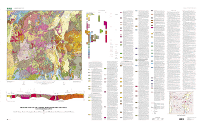
This database was developed to improve upon previous mapping in the central Marysvale volcanic field and compile older mapping at a consistent scale. This area is an important mining district, and a regional understanding of the geology and mineral deposits will assist in understanding genesis of deposits and in exploration for new deposits. The area is also an important part of the transition zone between the Colorado Plateau to the east and the Great Basin to the west. This tectonically significant province may hold keys to the style and mechanisms of continent-scale deformation in the Western United States.

How was the data set created?

  1. From what previous works were the data drawn?
    Williams (1996) (source 1 of 1)
    Williams, Van S., 1996, GSMCAD, a new computer program that combines the functions of the GSMAP and GSEDIT programs and is compatible with Microsoft Windows and ARC/INFO: U. S. Geological Survey Open-File Report 96-007.

    Type_of_Source_Media: disc
    Source_Contribution: software for digitizing linework
  2. How were the data generated, processed, and modified?
    Date: 1995 (process 1 of 5)
    Linework and labels digitized and attributed in GSMCAD (Williams, 1996).
    Date: 1997 (process 2 of 5)
    Map Reviewed by Karl Kellogg (USGS) and review edits made to data base in GSMCAD (Williams, 1996).
    Date: 1998 (process 3 of 5)
    Map reviewed by Gary Dixon (USGS) and review edits made to data base in GSMCAD (Williams, 1996).
    Date: 1999 (process 4 of 5)
    Data set imported into ARC/INFO (version 7.2.1), where coverages were built and cleaned to ensure logical consistency. Visual inspection of data and frequency tests run to ensure attribute accuracy. Data exported and compressed for publication and digital release.
    Date: 01-Oct-2004 (process 5 of 5)
    Creation of original metadata record Person who carried out this activity:
    Jeremiah B. Workman
    U. S. Geological Survey
    Box 25046
    Denver, CO
    USA

    303-236-1257 (voice)
    jworkman@usgs.gov
  3. What similar or related data should the user be aware of?
    Campbell, David L., Steven, Thomas A., Cunningham, Charles G., and Rowley, Peter D., 1999, Aeromagnetic and Gravity Maps of the Central Marysvale Volcanic Field, Southwestern Utah: U.S. Geological Survey Geologic Investigations Series I-2645-B, U.S. Geological Survey, Denver, CO.

    Online Links:


How reliable are the data; what problems remain in the data set?

  1. How well have the observations been checked?
    The database was digitized in GSMCAD (Williams, 1996), which does not allow unattributed lines so there are no unlabeled lines in the database. Frequency tests were run on the lines and polygon labels to ensure that no arcs or polygons are unlabeled. The attributes have been checked by the authors for agreement with field maps, annotated aerial photographs, and preliminary drafted versions of the map. The attribute data in the data set should be taken as an accurate representation of the authors' geologic interpretations.
  2. How accurate are the geographic locations?
    The estimated horizontal positional accuracy of the data is 15 meters. Mapping at 1:24,000-scale (1:50,000-scale in the northwest corner of the map area) was generalized to 1:100,000-scale. All linework was digitized at 1:24,000-scale by using a CalComp digitizing table (model 95482) having an error of +/-0.001 inches (< 1 meter at map scale). This database was produced to be used at 1:100,000-scale and any problems arising from use at other scales are not the responsibilities of the authors. No vertical data are included in the database.
  3. How accurate are the heights or depths?
  4. Where are the gaps in the data? What is missing?
    This dataset includes only the coverages pertaining to the geologic map. Supplemental text and illustrations on the printed map (correlation chart, explanation of map symbols, cross-section) are not included. This map was produced to be used at 1:100,000-scale. Any geologic features too small to be shown at this scale have been omitted or generalized if they are of significant importance. The smallest objects are approximately 40 meters on a side.
  5. How consistent are the relationships among the observations, including topology?
    The entire study area was mapped both by photo-interpretation and by extensive field work at 1:50,000- and 1:24,000-scale over the course of several decades. The entire map area was mapped at the same level of detail. All linework was digitized at 1:24,000-scale, except for parts of the northwestern corner of the map, which were digitized at 1:50,000-scale, and edits were made, adjoining quads edge-matched and snapped, and attributes were added using GSMCAD (Williams, 1996). All lines were visually inspected by the authors for proper intersections, repetition, overshoots, undershoots, and overall logical consistency. The geologic features in the map area are all described, in the view of the authors, at a consistent scale of 1:100,000. All coverages were cleaned and built in ARC/INFO (version 7.1.2) to ensure a logical consistency that is topologically clean.

How can someone get a copy of the data set?

Are there legal restrictions on access or use of the data?
Access_Constraints: None
Use_Constraints:
Acknowledgment of the U.S. Geological Survey would be appreciated in products derived from these data.
  1. Who distributes the data set? (Distributor 1 of 2)
    U. S. Geological Survey
    U. S. Geological Survey Central Publications Group
    Denver, CO
    USA

    303-236-5486 (voice)
  2. What's the catalog number I need to order this data set? Geologic Investigation Series I-2645-A, "Geologic Map of the Central Marysvale Volcanic Field, Southwestern Utah"
  3. What legal disclaimers am I supposed to read?
    Although these digital spatial data have been subjected to rigorous review and are substantially complete, they are released on the condition that neither the USGS nor the United States Government may be held liable for any damages resulting from their authorized or unauthorized use.
  4. How can I download or order the data?

  1. Who distributes the data set? (Distributor 2 of 2)
    U.S. Geological Survey
    U.S. Geological Survey Information Services
    Denver, CO
    USA

    1-888-ASK-USGS (voice)
  2. What's the catalog number I need to order this data set? USGS Geologic Investigation Series I-2645-A
  3. What legal disclaimers am I supposed to read?
    None
  4. How can I download or order the data?
    • Availability in non-digital form:
      Available as folded map, printed on a four-color press; order from USGS at address listed above.
    • Cost to order the data: http://store.usgs.gov/


Who wrote the metadata?

Dates:
Last modified: 13-Jun-2016
Metadata author:
Peter N Schweitzer
USGS Midwest Area
Collection manager, USGS Geoscience Data Clearinghouse, http://geo-nsdi.er.usgs.gov/
Mail Stop 954
12201 Sunrise Valley Dr
Reston, VA
USA

703-648-6533 (voice)
703-648-6252 (FAX)
pschweitzer@usgs.gov
Metadata standard:
Content Standard for Digital Geospatial Metadata (FGDC-STD-001-1998)

This page is <https://geo-nsdi.er.usgs.gov/metadata/map-i/2645/a/metadata.faq.html>
Generated by mp version 2.9.48 on Tue Jul 03 20:04:50 2018