Geologic Map of the Tularosa Mountains 30´ × 60´ Quadrangle, Catron County, New Mexico

Metadata also available as - [Outline] - [Parseable text] - [XML]

Frequently anticipated questions:


What does this data set describe?

Title:
Geologic Map of the Tularosa Mountains 30´ × 60´ Quadrangle, Catron County, New Mexico
Abstract:
This digital map database was compiled from previously published and unpublished data by the author and USGS colleagues, and from published maps by others, as indicated in figure 3 on the map sheet. A pamphlet included with the map provides a brief discussion of the geology of the quadrangle, a description of map units, and references cited.
Supplemental_Information:
The dataset for the Tularosa Mountains quadrangle consists of six coverages:
tulgeop
tulflt
tulgline
tulgpnt
tuldpnt
tullndec
The coverage tullndec is not a "true" ARC/INFO coverage. It consists of various symbols drawn as arcs.
Also included are the following files, which are used to run the Plot AML in ArcInfo:
tulplot.aml -- ArcInfo aml used to create a graphics file
tulplot.gra -- ArcInfo graphics file
alcgeol.mrk -- ArcInfo marker set
dike.lin -- ArcInfo line set
dtpt.mrk -- ArcInfo marker set
fnt039 -- ArcInfo font used in dtpt.mrk
Also included is a georeferenced TIFF image (tulrec.tif) derived from a scan of the Tularosa Mountains quadrangle topographic base map on scale-stable film. The accompanying file called tulrec.tfw is a file generated during rectification of the tiff image in ArcInfo and is needed to use the file tulrec.tif in some applications.
  1. How might this data set be cited?
    Ratte, James C., 2001, Geologic Map of the Tularosa Mountains 30´ × 60´ Quadrangle, Catron County, New Mexico: U.S. Geological Survey Geologic Investigations Series Map I-2619, U.S. Geological Survey, Denver, Colorado.

    Online Links:

    Other_Citation_Details:
    Prepared in cooperation with the New Mexico Bureau of Mines and Mineral Resources, a division of the New Mexico Institute of Mines and Technology
  2. What geographic area does the data set cover?
    West_Bounding_Coordinate: -109.00
    East_Bounding_Coordinate: -108.00
    North_Bounding_Coordinate: 34.00
    South_Bounding_Coordinate: 33.50
  3. What does it look like?
    http://pubs.usgs.gov/imap/i-2619/i-2619.gif (GIF)
    Reduced-size image of the entire map sheet, 400x281 pixels, 67k bytes.
    http://pubs.usgs.gov/imap/i-2619/i-2619_print.pdf (PDF)
    Complete map layout, including a correlation diagram, list of map units, and supplemental illustrations. An accompanying pamphlet contains interpretive text, complete descriptions of map units, and list of references cited.
  4. Does the data set describe conditions during a particular time period?
    Calendar_Date: 2001
    Currentness_Reference:
    publication date
  5. What is the general form of this data set?
    Geospatial_Data_Presentation_Form: map
  6. How does the data set represent geographic features?
    1. How are geographic features stored in the data set?
      This is a Vector data set.
    2. What coordinate system is used to represent geographic features?
      Grid_Coordinate_System_Name: Universal Transverse Mercator
      Universal_Transverse_Mercator:
      UTM_Zone_Number: 12
      Transverse_Mercator:
      Scale_Factor_at_Central_Meridian: 0.9996
      Longitude_of_Central_Meridian: -111.0
      Latitude_of_Projection_Origin: 0.0
      False_Easting: 500000.0
      False_Northing: 0.0
      Planar coordinates are encoded using coordinate pair
      Abscissae (x-coordinates) are specified to the nearest 0.000048
      Ordinates (y-coordinates) are specified to the nearest 0.000048
      Planar coordinates are specified in meters
      The horizontal datum used is North American Datum of 1927.
      The ellipsoid used is Clarke 1866.
      The semi-major axis of the ellipsoid used is 6378206.4.
      The flattening of the ellipsoid used is 1/294.98.
  7. How does the data set describe geographic features?
    Entity_and_Attribute_Overview:
    The dataset for the Tularosa Mountains quadrangle consists of six coverages:
    tulgeop
    tulflt
    tulgline
    tulgpnt
    tuldpnt
    tullndec
    
    The coverage tullndec is not a "true" ARC/INFO coverage. It consists of various symbols drawn as arcs.
    The tulgeop coverage consists of polygons that are map units and arcs that are contacts and color boundaries (other than contacts).
    The tulgeop.pat INFO file consists of the following items:
    TYPE--Refers to the type of polygon: in this database the only type in this coverage is "map unit." To interpret the map unit symbols, refer to the explanation of unit symbols as coded by NAME.
    NAME--Refers to the map unit name and associated symbol.
    Items in tulgeop.pat are defined as follows:
    SURFICIAL DEPOSITS
    Qa  Alluvium (Holocene)
    Qsa  Playa alluvium of the Plains of San Agustin (Holocene)
    Deposits of prehistoric lake San Agustin
    Qsb  Bar and barrier ridge deposits (Holocene and Pleistocene)
    Qsfd  Fan delta deposits (Holocene and Pleistocene)
    Qss  Shoreline deposits (Holocene and Pleistocene)
    Qac  Colluvium and alluvium (Holocene and Pleistocene)
    Ql  Landslide deposits (Holocene and Pleistocene)
    Qp  Piedmont slope deposits (Pleistocene)
    VOLCANIC AND VOLCANICLASTIC ROCKS
    Volcaniclastic rocks of the Gila Group
    QTg   Gila Group, undivided (Pleistocene(?) to early Miocene)
    QTgu  Upper Gila Group (Pleistocene(?) to middle Miocene)
    QTgl  Lower Gila Group (middle to early Miocene)
    QTs   Volcaniclastic rocks of the Santa Fe Group (Pleistocene to Miocene)
    Volcanic rocks interlayered with the Gila Group
    QTb   Basalt (Pleistocene and Pliocene, 0.9-2.5 Ma)
    QTd   Basalt dikes (Pleistocene and Pliocene)
    QTbc  Basalt scoria (Pleistocene and Pliocene)
    Tb    Basalt, andesite, and dacite, undivided (Miocene)
    Tbd   Basalt dikes (Miocene)
    Tbcc  Basaltic scoria, cinders, and bombs (Miocene)
    Tfb   Basalt on Flat Top Mesa (Miocene, 9 Ma) Rocks of Apache Peak volcano
    Taa   Andesite at Apache Peak (Miocene, 10.6 Ma)
    Rocks of Eagle Peak volcano
    Tedp  Central dacite plug (Miocene, 11.4 Ma)
    Tedu  Upper dacite flows (Miocene)
    Tedl  Lower andesite and dacite flows (Miocene, 12 Ma)
    Tedw  Wilson Canyon andesite flows (Miocene)
    Tedm  Milligan Mountain andesite-dacite flows Miocene, 12 Ma)
    Ted   Andesite dike at Dry Mesa (Miocene)
    Rocks of Horse Mountain volcano
    Thv   Predominantly dacitic, rhyolitic to andesitic lava flows  (Miocene, 12-14 Ma)
    Thd   Northwest-trending, andesitic-dacitic breccia dikes (Miocene)
    Tht   Pyroclastic rocks (Miocene)
    Thp   Dacite plug (Miocene)
    Thdr  Aplite dikes (Miocene)
    Thb   Vent(?) breccia (Miocene)
    Tha   Megacrystic andesite lava flow (Miocene, 12 Ma)
    Tsb   Basalt of Saliz Hill (Miocene, 12.2 Ma)
    Tkb   Basalt at Kiehnes Canyon (Miocene, 13.5 Ma)
    Rocks of John Kerr Peak volcano
    Tjr   Rhyolite domes and flows (Miocene,13 Ma)
    Tmr   Rhyolite near Maverick Peak  (Miocene, 14 Ma)
    Tmrd  Rhyolite dike in rhyolite near Maverick Peak (Miocene)
    Tli   Porphyritic quartz-diorite intrusions at Wet Leggett Spring (Miocene,15 Ma)
    Volcaniclastic rocks of the Spears Group (Oligocene and Eocene)
    Tsu   Upper Spears Group (Oligocene)
    Tsl   Lower Spears Group, undivided (Oligocene and Eocene)
    Tslw  White sandstone sequence of lower Spears Group (Eocene)
    Tslg  Green to gray sandstone sequence of lower Spears Group (Eocene)
    Tpu   Upper Pueblo Creek Formation (Oligocene and Eocene)--Units Tt and Tt1-4 are discontinuous, thin (0 to about 5 m thick) Datil Group ignimbrites interlayered in upper Pueblo Creek Formation
    Tpl   Lower Pueblo Creek Formation (Eocene)
    Volcanic rocks of the Mogollon Group (Miocene and Oligocene)
    Tmgu  Mogollon Group, undivided (Miocene and Oligocene)
    Tad   Andesite dikes (Miocene and Oligocene)
    Bearwallow Mountain Andesite (Oligocene, 25-26 Ma)
    Tba   Basaltic-andesite to dacite lava flows (Oligocene)
    Tbad  Andesitic dike (Oligocene)
    Tbap  Andesite plugs (Oligocene)
    Tbac  Andesitic cinder and scoria deposits(Oligocene)
    Thr   Rhyolite of Hay Canyon (Oligocene?)
    Tfr   Rhyolite at Frying Pan Creek (Oligocene?)
    Tsr   Rhyolite of Stallings Tank (Oligocene)
    Tct   Tuff of Triangle C Ranch (Oligocene, 28.1 Ma)
    Tbt   Bloodgood Canyon Tuff (Elston, 1976)(Oligocene, 28.1 Ma)
    Tca   Basaltic-andesite of Cottonwood Canyon (Oligocene)
    Tst   Shelley Peak Tuff (Oligocene, 28.1 Ma)
    Taylor Creek Rhyolite and associated rocks
    Tgt   Tuff of Garcia Camp (Oligocene, 28.1 Ma)
    Ttr   Taylor Creek Rhyolite (Oligocene, 28.1 Ma)
    Tsa   Squirrel Springs Canyon Andesite(Oligocene, 28.5 Ma)
    Tvt   Vicks Peak Tuff(Oligocene, 28.6 Ma)
    Tgr   Rhyolite of Gwynn Canyon (Oligocene, 28.7 Ma)
    Tlt   La Jencia Tuff (Oligocene, 28.9 Ma)
    Tdt   Davis Canyon Tuff (Oligocene, 29.0 Ma)
    Ta    Andesite flows (Oligocene)
    Tbr   Rhyolite of Bat Cave Wells(Oligocene)
    Rocks of Telephone Canyon volcano
    Tta   Andesite of Telephone Canyon, undivided (Oligocene, 32.9-29.7 Ma)
    Volcanic rocks of the Datil Group (Oligocene and Eocene)
    Tdgu  Datil Group, undivided (Oligocene and Eocene)
    Tcbt  Caballo Blanco Tuff(Oligocene, 31.6 Ma)
    Thmt  Hells Mesa Tuff (Oligocene, 32.1 Ma)
    Tt    Distal outflow of regional ignimbrites (Oligocene and Eocene)-- Labeled Tt-Tt4 where present in sequence
    Rocks of Saddle Mountain volcano
    Tas   Andesite lava flows (earliest Oligocene or latest Eocene, about 33.3 Ma)
    Tasb  Andesite agglomerate (Oligocene or Eocene)
    Tasd  Andesite dikes (Oligocene or Eocene)
    Tsca  Andesitic intrusive-extrusive complex of Saliz Canyon (Eocene)
    Tscb  Andesitic vent(?) breccia (Eocene, 33.6 Ma>
    Tla   Andesite of Dry Leggett Canyon (Eocene)
    Tlai  Possible plug or vent for andesite of Dry Leggett Canyon (Eocene)
    Rocks of Horse Springs volcano or volcanic center
    Thsd  Horse Springs dacite (Eocene, 33.7 Ma)
    Thsb  Megabreccia and mesobreccia (Eocene)
    Tbct  Blue Canyon Tuff (Eocene, 33.7 Ma)
    Trt   Rock House Canyon Tuff (Eocene, 34.4 Ma)
    Tbrt  Blue Canyon and Rock House Canyon Tuffs, undivided (Eocene)
    Tlwt  Tuff of Lebya Well (Eocene, 34.7 Ma)
    Tpt   Tuff of Bishop Peak (Eocene, 34.6 Ma)
    Tkt   Kneeling Nun Tuff (Eocene, 34.9 Ma)
    Tft   Tuff of Farr Ranch(Eocene, 35.6 Ma)
    Twt   Datil Well Tuff (Eocene 35.5 Ma)
    Twft  Datil Well Tuff and (or) tuff of Farr Ranch, undivided (Eocene)
    Tac   Basaltic lava flow of Alamocito Canyon (Eocene)
    
    OLDER SEDIMENTARY ROCKS
    Sedimentary rocks, undivided (Permian)
    
    The tulgeop.aat INFO file consists of the following items:
    TYPE_L--Refers to the type of arc and is one of the following: "contact" or "colorboundary."
    ACCURACY--Refers to accuracy of location of arcs in the gpoly coverage and is one of the following: "certain" or "gradational" (used between facies of the Upper Pueblo Creek Formation).
    The tulflt coverage consists of arcs that are faults.
    The tulflt.aat INFO file consists of the following items:
    TYPE--Refers to the type of arc; the only type in this coverage is "fault."
    FAULTTYPE--Refers to the type of fault; the only type in this coverage is "normal."
    ACCURACY--Refers to accuracy of location of arcs in the tulflt coverage and is one of the following: "certain," "approximate," or "concealed."
    DIPVALUE--Refers to amount of dip on fault, in degrees, where known; a value of 0 was arbitrarily entered in this field for faults where no dip was determined or known.
    DIPDIRECTION--Refers to direction of dip on fault, where known, and is given as N (north), NE (northeast), E (east), SE (southeast), S (south), SW (southwest), W (west), or NW (northwest).
    The tulgline coverage consists of arcs that are landslide scarps, caldera margins, tuffs, dikes, or fault/dikes (dikes that intrude faults).
    The tulgline.aat INFO file consists of the following items:
    TYPE--Refers to the type of arc and is one of the following: "dike," "fault/dike," "tuff," "landslide scarp," or "caldera margin."
    ACCURACY--Refers to accuracy of location of caldera margin in the tulline coverage; the caldera margin is coded as "inferred."
    NAME--Applicable only to "dike," "fault/dike," or "tuff" and refers to the map unit name or, in the case of an unnamed rhyolite dike, the symbol "rd."
    Items in tulgline.aat are defined as follows:
    Volcanic rocks interlayered with the Gila Group
    QTd   Basalt dikes (Pleistocene and Pliocene)
    Tbd   Basalt dikes (Miocene)
    Rocks of Eagle Peak volcano
    Ted   Andesite dike at Dry Mesa (Miocene)
    Rocks of Horse Mountain volcano
    Thd   Northwest-trending, andesitic-dacitic brecciadikes (Miocene)
    Thdr  Aplite dikes (Miocene)
    Rhyolite near Maverick Peak  (Miocene, 14 Ma)
    Tmrd  Rhyolite dike in rhyolite near Maverick Peak (Miocene)
    Volcanic rocks of the Mogollon Group (Miocene and Oligocene)
    Tad   Andesite dikes (Miocene and Oligocene)
    Bearwallow Mountain Andesite (Oligocene, 25-26 Ma)
    Tbad  Andesite dike (Oligocene)
    Volcanic rocks of the Datil Group (Oligocene and Eocene)
    Tt    Distal outflow of regional ignimbrites (Oligocene and 	Eocene)-- Labeled Tt2-4 where present in sequence
    Rocks of Saddle Mountain volcano
    Tasd  Andesite dikes (Oligocene or Eocene)
    Tpt   Tuff of Bishop Peak (Eocene, 34.6 Ma)
    rd    Rhyolite dike (mapped only in Upper Pueblo Creek Formation and in Bloodgood Canyon Tuff)
    
    The tulgpnt coverage consists of points that are localities of strike and dip measurements on sedimentary bedding surfaces and compaction foliation of ignimbrites (ash-flow tuffs); also includes locations of volcanic centers or vents.
    The tulgpnt.pat INFO file consists of the following items:
    TYPE--Refers to the type of point or surface measured and is one of the following: "bedding surface," "foliation," or "volcanic center/vent."
    DIPVALUE--Refers to the angle made by the intersection of the bedding surface or foliation with the horizontal; ranges from 0º to 90º
    VOLCANICNUMBER--Refers to number assigned to a volcanic center or vent for descriptive purposes; volcanic centers and vents are numbered 1-26
    POSITION--Refers to the attitude of measured surfaces and is one of the following: "inclined" or "horizontal."
    ACCURACY--Refers to the accuracy of the strike and dip of surfaces and is one of the following: "measured" or "apparent."
    SYMBOLANGLE--Refers to the rotation of the symbol used to plot the feature; NOT a measurement of actual orientation of the feature (see STRIKEANGLE for the compass quadrant bearing).
    STRIKEANGLE--Refers to the trend of a surface as it intersects the horizontal; recorded as compass quadrant bearings, e.g., N66W
    DIPDIRECTION--Refers to direction of dip of bedding surface or foliation, and is given as N (north), NE (northeast), E (east), SE (southeast), S (south), SW (southwest), W (west), or NW (northwest).
    VOLCANICAGE--Refers to the age of the volcanic center or vent in millions of years (Ma), where determined.
    The tuldpnt coverage consists of points that are locations of test wells and road metal quarries.
    The tuldpnt.pat INFO file consists of the following items:
    GEOCODE--Refers to the type of point and is one of the following: "oil well," "climate well," or "quarry."
    NAME--Gives the full name of the well, either "SWEPI No. 1 oil test well" or "600-m Oberlin University climate test well."
    The tullndec coverage consists of arcs that are line decorations: bar and ball symbols that show displacement on faults, arrows that show dip direction on faults, and arrows used to indicate the gradational contact between facies of the upper Pueblo Creek Formation of the Spears Group (annotations: AF, alluvial facies; VF, vent facies).
    The tullndec.aat INFO file consists of the following items:
    DIPVALUE--Refers to amount of dip on fault, in degrees, where known; a value of 0 was arbitrarily entered in this field for faults where no dip was determined or known.
    DIPDIRECTION--Refers to direction of dip of a fault, and is given as N (north), NE (northeast), E (east), SE (southeast), S (south), SW (southwest), W (west), or NW (northwest).
    Entity_and_Attribute_Detail_Citation: http://pubs.usgs.gov/imap/i-2619/i-2619_p.pdf

Who produced the data set?

  1. Who are the originators of the data set? (may include formal authors, digital compilers, and editors)
    • James C. Ratte
  2. Who also contributed to the data set?
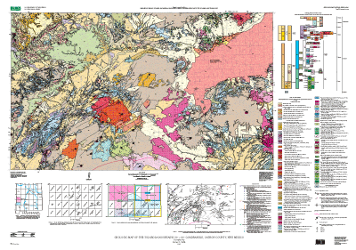
    The geologic map was compiled by James C. Ratte, U.S. Geological Survey. The draft compilation was scribed for scanning by Joe Romero and converted to digital form by Mark M. Mansell, K.E. Fresch, and G.E. Jones, New Mexico Bureau of Mines and Mineral Resources; and Nancy Shock and Diane E. Lane, U.S. Geological Survey. The map was edited and the digital database proofread by Diane E. Lane.
  3. To whom should users address questions about the data?
    James C. Ratte
    U.S. Geological Survey
    Box 25046, MS905
    Denver, CO
    USA

    303-236-5618 (voice)
    jratte@usgs.gov

Why was the data set created?

The map in intended to provide (1) regional geologic information at a scale (1:100,000) intermediate between that of the new New Mexico State Geologic Map (scale 1:500,000) and individual 7½- and 15-minute geologic quadrangles at 1:24,000 and 1:62,500, respectively, of part of the western part of the Mogollon-Datil volcanic field; and (2) updated, detailed information on the ages, sources, distribution, and correlation of caldera-related ignimbrites (ash-flow tuffs), and associated extrusive and intrusive volcanic rocks in the northwestern part of the Mogollon-Datil volcanic field. The ignimbrites are mainly outflow from the major Oligocene and Eocene caldera eruptive centers in adjacent areas, but the Tularosa Mountains 30´ × 60´ quadrangle also contains numerous eruptive centers of post-caldera age, which are aligned along major structural trnds of basin and range age (~ 20–1 million years), and constitute a basaltic to silicic, bimodal volcanic assemblage.

How was the data set created?

  1. From what previous works were the data drawn?
  2. How were the data generated, processed, and modified?
    Date: 1999 (process 1 of 7)
    Staff of the New Mexico Bureau of Mines and Mineral Resources scanned source stable-base material, vectorized scan, attributed files from author drafting and annotations, and produced check plots and coverages.
    Date: 1999 (process 2 of 7)
    Author and map editor proofread check plots, and digital map specialist reviewed digital files.
    Date: 2000 (process 3 of 7)
    Staff of the New Mexico Bureau of Mines and Mineral Resources corrected attributing as needed and produced new check plots.
    Date: 2000 (process 4 of 7)
    Digital map specialist and map editor proofread new check plots and reviewed digital files, making final corrections as needed.
    Date: 2001 (process 5 of 7)
    Map editor imported files into graphics program to prepare cartographic product.
    Date: 2001 (process 6 of 7)
    Cartographic product printed; digital files for database corrected for errors discovered in the cartographic phase of production; dataset and PDF files of cartographic product placed on ftp server.
    Date: 04-Feb-2003 (process 7 of 7)
    Creation of original metadata record Person who carried out this activity:
    Diane E. Lane
    U.S. Geological Survey, Geologic Division, Central Publications Group
    Geologic Map Editor
    Box 25046, MS902
    Denver, CO
    USA

    303-236-5476 (voice)
    303-236-6287 (FAX)
    delane@usgs.gov
  3. What similar or related data should the user be aware of?

How reliable are the data; what problems remain in the data set?

  1. How well have the observations been checked?
    Staff of New Mexico Bureau of Mines and Mineral resources scanned source stable-base material, vectorized scan, attributed files from author drafting and annotations, and produced check plots and coverages. Author and map editor (U.S. Geological Survey) proofread check plots, and digital map specialist reviewed digital files. Digital map specialist and map editor corrected linework and attributing as needed and produced new check plots. Digital map specialist and editor proofread new check plots and reviewed digital files, making final corrections as needed; editor imported files into graphics program to prepare cartographic product. Author proofread cartographic product (the map sheet layout and pamphlet). Digital Map Specialist and map editor made final changes to correct attribute errors discovered in the process of cartographic production. They generated frequency tables to identify errors in attribute spelling and unattributed features. This map was thoroughly reviewed for conformity with U.S. Geological Survey editorial standards and stratigraphic nomenclature.
  2. How accurate are the geographic locations?
    The accuracy of location of polygons, lines, and points is consistent with the map scale of 1:100,000.
  3. How accurate are the heights or depths?
  4. Where are the gaps in the data? What is missing?
  5. How consistent are the relationships among the observations, including topology?
    Polygon and node topology are present. All polygons are labeled and were tested by using the ArcInfo command LABELERRORS. All polygons were checked for closure, node errors, overshoots, undershoots, dangles, and intersections by using ArcInfo routines. The ArcInfo commands BUILD and CLEAN were run to ensure the topological consistency of the dataset.

How can someone get a copy of the data set?

Are there legal restrictions on access or use of the data?
Access_Constraints: none
Use_Constraints:
none. Acknowledgment of the U.S. Geological Survey would be appreciated in products derived from these data.
  1. Who distributes the data set? (Distributor 1 of 1)
    U.S. Geological Survey Information Services
    Box 25286
    Denver, CO
    USA

    1-888-ASK-USGS (voice)
  2. What's the catalog number I need to order this data set? Miscellaneous Geologic Investigations Series I-2619, "Geologic Map of the Tularosa Mountains Quadrangle, Catron County, New Mexico"
  3. What legal disclaimers am I supposed to read?
    Any use of trade, product, or firm names is for descriptive purposes only and does not imply endorsement by the U.S. Government. Although this data set has been used by the U.S. Geological Survey, no warranty, expressed or implied, is made by the USGS as to the accuracy and functioning of the data set and related material nor shall the fact of distribution constitute any such warranty, and no responsibility is assumed by the USGS in connection therewith.
  4. How can I download or order the data?

Who wrote the metadata?

Dates:
Last modified: 13-Jun-2016
Metadata author:
Peter N Schweitzer
USGS Midwest Area
Collection manager, USGS Geoscience Data Clearinghouse, http://geo-nsdi.er.usgs.gov/
Mail Stop 954
12201 Sunrise Valley Dr
Reston, VA
USA

703-648-6533 (voice)
703-648-6252 (FAX)
pschweitzer@usgs.gov
Metadata standard:
Content Standard for Digital Geospatial Metadata (FGDC-STD-001-1998)

This page is <https://geo-nsdi.er.usgs.gov/metadata/map-i/2619/metadata.faq.html>
Generated by mp version 2.9.48 on Tue Jul 03 20:04:48 2018