The dataset for the Lake Erie quadrangle consists of 10 coverages.
       geo_net
       gla_lin
       gla_pnt
       hydr_lin
       topo_lin
       bnd_lin
       bnd_net
       rd_lin
       rr_lin
       grid_lin
The dataset also includes an ARC/INFO AML, lineset, shadeset, and
markerset that will produce the EPS file of the geology and glacial
features and the list of map units.
Online Links:
Online Links:
GEOCODE	MAPUNITS, (AGE)

lm	LAKE CLAY AND SILT (under Lakes Huron, Erie, and Ontario),
	   (HOLOCENE)
ls	LAKE SAND AND GRAVEL (under Lakes Huron, Erie, and Ontario),
	   (HOLOCENE)
al	ALLUVIUM (HOLOCENE AND LATE WISCONSIN)
lc	LAKE SILT AND CLAY (under Lakes Huron, Erie, and Ontario),
        (HOLOCENE AND LATE WISCONSIN)
lcb	LAKE CLAY, SILT, SAND, AND GRAVEL (under Lakes St. Clair
	   and Erie), (HOLOCENE AND LATE WISCONSIN)
lcc	LAKE CLAY, SILT, SAND, AND GRAVEL (HOLOCENE AND
        LATE WISCONSIN)
lca	LAKE SILT AND CLAY (HOLOCENE AND LATE WISCONSIN)
lsa	LAKE SAND AND GRAVEL (HOLOCENE AND LATE WISCONSIN)
hs	SWAMP DEPOSIT (HOLOCENE AND LATE WISCONSIN)
hp	PEAT (HOLOCENE AND LATE WISCONSIN)
ed	DUNE SAND (HOLOCENE AND LATE WISCONSIN)
eu	EOLIAN SAND AND SILT (HOLOCENE AND LATE WISCONSIN)
cbb	BOULDERY COLLUVIUM AND ROCK WASTE (HOLOCENE AND WISCONSIN)
cl	LOAMY COLLUVIUM (HOLOCENE AND WISCONSIN)
clc	LOAMY COLLUVIUM (HOLOCENE AND WISCONSIN)
cld	LOAMY COLLUVIUM  (HOLOCENE AND WISCONSIN)
jla	LOAMY COLLUVIUM AND LANDSLIDE DEPOSITS--Areas with abundant
	   or widely distributed landslide deposits (HOLOCENE AND
	   WISCONSIN)
jlb	LOAMY COLLUVIUM AND LANDSLIDE DEPOSITS--Areas with scattered
	   or localized landslide deposits (HOLOCENE AND WISCONSIN)
Tills in Michigan, Ohio, Pennsylvania, and New York
tc	CLAYEY TILL, Ground moraine, (LATE WISCONSIN)
tc	CLAYEY TILL, End moraine (LATE WISCONSIN)
tcd	CLAYEY TILL, Ground moraine under Lake Erie, (LATE WISCONSIN)
tcd	CLAYEY TILL, End moraine, (LATE WISCONSIN)
tca	CLAYEY TILL, Ground moraine, (LATE WISCONSIN)
tca	CLAYEY TILL, Ground moraine under Lake Erie, (LATE WISCONSIN)
tca	CLAYEY TILL, Ground moraine veneer (LATE WISCONSIN)
tca	CLAYEY TILL, End moraine (LATE WISCONSIN)
tcb	CLAYEY TILL, Ground moraine (LATE WISCONSIN)
tcb	CLAYEY TILL, Stagnation moraine, (LATE WISCONSIN)
tcb	CLAYEY TILL, End moraine (LATE WISCONSIN)
tcg	CLAYEY TILL, Ground moraine (LATE WISCONSIN)
tcg	CLAYEY TILL, Ground moraine veneer (LATE WISCONSIN)
tl	LOAMY TILL, Ground moraine (LATE WISCONSIN)
tl	LOAMY TILL, Ground moraine under Lake Huron, (LATE WISCONSIN)
tl	LOAMY TILL, Ground moraine veneer (LATE WISCONSIN)
tl	LOAMY TILL, Stagnation moraine, (LATE WISCONSIN)
tl	LOAMY TILL, End moraine (LATE WISCONSIN)
tlb	LOAMY TILL, Ground moraine, (LATE WISCONSIN)
tlb	LOAMY TILL, Ground moraine veneer (LATE WISCONSIN)
tlb	LOAMY TILL, End moraine (LATE WISCONSIN)
tld	LOAMY TILL, Ground moraine, (LATE WISCONSIN)
tld	LOAMY TILL, End moraine (LATE WISCONSIN)
tlg	LOAMY TILL, Ground moraine (LATE WISCONSIN)
tlg	LOAMY TILL, Ground moraine under Lakes Erie and Ontario
	   (LATE WISCONSIN)
tlg	LOAMY TILL, Ground moraine veneer (LATE WISCONSIN)
tlg	LOAMY TILL, Stagnation moraine (LATE WISCONSIN)
tlg	LOAMY TILL, End moraine (LATE WISCONSIN)
tlr	LOAMY TILL, Attenuated drift (LATE WISCONSIN)
tlh	LOAMY TILL, Ground moraine (LATE WISCONSIN)
tlh	LOAMY TILL, End moraine (LATE WISCONSIN)
td	SANDY LOAMY TILL, Ground moraine (LATE WISCONSIN)
td	SANDY LOAMY TILL, End moraine (LATE WISCONSIN)
Tills in Ontario (Ground moraine and end moraine not distinguished)
tap	CLAYEY TILL (LATE WISCONSIN)
taa	CLAYEY TILL (LATE WISCONSIN)
tab	CLAYEY TILL, Ground moraine and end moraine (LATE WISCONSIN)
tab	CLAYEY TILL, Ground moraine and end moraine under Lakes
	   Erie and Ontario (LATE WISCONSIN)
tak	CLAYEY TILL, Ground moraine and end moraine (LATE WISCONSIN)
tak	CLAYEY TILL, Ground moraine under Lake Huron
        (LATE WISCONSIN)
taq	CLAYEY TILL (LATE WISCONSIN)
tae	CLAYEY TILL, Ground moraine and end moraine, (LATE WISCONSIN)
tae	CLAYEY TILL, Ground moraine and end moraine under Lake Erie
	   (LATE WISCONSIN)
tai	CLAYEY TILL (LATE WISCONSIN)
tao	CLAYEY TILL (LATE WISCONSIN)
taf	CLAYEY TILL (LATE WISCONSIN)
tka	LOAMY TILL, Ground moraine and end moraine (LATE WISCONSIN)
tka	LOAMY TILL, Ground moraine and end moraine under Lake Ontario
(LATE WISCONSIN)
tkk	LOAMY TILL, Ground moraine and end moraine (LATE WISCONSIN)
tkk	LOAMY TILL, Ground moraine and end moraine under Lake Erie
	   (LATE WISCONSIN)
tkl	LOAMY TILL (LATE WISCONSIN)
tkg	LOAMY TILL (LATE WISCONSIN)
tkn	LOAMY TILL (LATE WISCONSIN)
tkh	LOAMY TILL (LATE WISCONSIN)
tko	LOAMY TILL (LATE WISCONSIN)
tkf	LOAMY TILL (LATE WISCONSIN)
tki	LOAMY TILL (LATE WISCONSIN)
teb	SANDY LOAMY TILL (LATE WISCONSIN)
kg	ICE-CONTACT SAND AND GRAVEL (LATE WISCONSIN)
ks	ICE-CONTACT SAND (LATE WISCONSIN)
ke	KAME END MORAINE (LATE WISCONSIN)
gg	OUTWASH SAND AND GRAVEL (LATE WISCONSIN)
gs	OUTWASH SAND (LATE WISCONSIN)
gkl	OUTWASH SAND AND GRAVEL (LATE WISCONSIN)
lcr	ATTENUATED LAKE SILT AND CLAY (LATE WISCONSIN)
lla	SLACKWATER LAKE SILT AND SAND (LATE WISCONSIN)
nlc	LOAMY SOLIFLUCTION DEPOSITS (LATE WISCONSIN)
lch	LAKE SAND, SILT, AND CLAY (LATE WISCONSIN AND MIDDLE WISCONSIN)
lcj	LAKE SAND, SILT, AND CLAY (WISCONSIN)
lgk	LAKE GRAVEL, SAND, SILT, AND CLAY (WISCONSIN)
tar	CLAYEY TILL (EARLY WISCONSIN)
tlj	LOAMY TILL (EARLY WISCONSIN)
tle	LOAMY TILL (EARLY WISCONSIN)
tdg	SANDY LOAMY TILL (EARLY WISCONSIN)
kgb	ICE-CONTACT SAND AND GRAVEL (EARLY WISCONSIN)
nma	CLAYEY TO SANDY SOLIFLUCTION DEPOSITS (WISCONSIN AND
	   ILLINOIAN)
nla	LOAMY SOLIFLUCTION DEPOSITS (WISCONSIN AND ILLINOIAN)
nlb	LOAMY SOLIFLUCTION DEPOSITS (WISCONSIN AND ILLINOIAN)
gga	OUTWASH SAND AND GRAVEL (EARLY WISCONSIN AND ILLINOIAN)
llb	SLACKWATER LAKE SILT AND SAND (EARLY WISCONSIN AND
        ILLINOIAN)
tcm	CLAYEY TILL, Ground moraine (ILLINOIAN)
tcm	CLAYEY TILL, End moraine (ILLINOIAN)
tlm	LOAMY TILL (ILLINOIAN)
tlo	LOAMY TILL (ILLINOIAN)
kgi	ICE-CONTACT SAND AND GRAVEL (ILLINOIAN)
ggi	OUTWASH SAND AND GRAVEL (ILLINOIAN)
lci	LAKE CLAY AND SILT (ILLINOIAN)
lle	LAKE SAND, SILT, AND CLAY (ILLINOIAN AND PRE-ILLINOIAN)
rci	LOAMY TO CLAYEY SOLUTION RESIDUUM (QUATERNARY)
zla	LOAMY DECOMPOSITION RESIDUUM (QUATERNARY)
zlb	LOAMY DECOMPOSITION RESIDUUM (QUATERNARY)
R	BEDROCK, (PRE-QUATERNARY)
f	MANMADE LAND
The geo_net.aat INFO file consists of the following item:
LTYPE--Refers to the type of arc and is one of the following:
"contact", "shoreline", "map boundary", or "null".
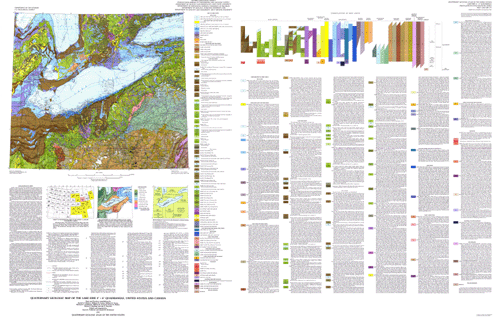
The Quaternary Geologic Map of the Lake Erie 4° x 6° Quadrangle, United States and Canada, I-1420 (NK-17) was compiled by David S. Fullerton and Jay A. Strathers, U.S. Geological Survey; William R. Cowan, Ontario Geological Survey; William D. Sevon, Pennsylvania Bureau of Topographic and Geologic Survey; Richard P. Goldthwait, Department of Geology and Mineralogy, Ohio State University; William R. Farrand, Department of Geological Sciences, University of Michigan; Ernest H. Muller, Department of Geology, Syracuse University; and Robert E. Behling, Department of Geology and Geography, West Virginia University. The state and province compilations were edited and integrated by Gerald M. Richmond, and David S. Fullerton, U.S. Geological Survey. The compilations of geology and glacial features were converted to digital form by Techni Graphic Systems, Inc., of Fort Collins, CO, under contract with the U.S. Geological Survey and modified by Charles A. Bush. Illustrations, wordprocessor files and DLG coverages were prepared by Bush and Wallace K. Fisk, U.S. Geological Survey.
In recent years, surficial deposits and materials have become the focus of much interest by scientists, environmentalists, governmental agencies, and the general public. They are the foundations of ecosystems, the materials that support plant growth and animal habitat, and the materials through which travels much of the water required for our agriculture, our industry, and our general well being. They also are materials that easily can become contaminated by pesticides, fertilizers, and toxic wastes. In this context, the value of the surficial geologic map is evident
Are there legal restrictions on access or use of the data?Access_Constraints: None
Use_Constraints:Acknowledgment of the Quaternary Geologic Atlas of the United States of America and (or) the U.S. Geological Survey in products derived from these data will be appreciated.
Any use of trade, product, or firm names is for descriptive purposes only and does not imply endorsement by the U.S. Government. Although this data set has been used by the U.S. Geological Survey, no warranty, expressed or implied, is made by the USGS as to the accuracy and functioning of the data set and related material nor shall the fact of distribution constitute any such warranty, and no responsibility is assumed by the USGS in connection therewith.
| Data format: | Geologic units and glacial features in format ARCE (version 7.2.1) Size: 14.6 |
|---|---|
| Network links: |
http://pubs.usgs.gov/imap/i-1420/nk-17/lakeerieGIS.zip |
| Data format: | Geologic units and glacial features in format Shapefile (version 1.0) Size: 14.6 |
|---|---|
| Network links: |
http://pubs.usgs.gov/imap/i-1420/nk-17/lakeerieAV.zip |